- Minnie Maud
-
Coordinates: 39°46′30″N 110°30′36″W / 39.775°N 110.51°W
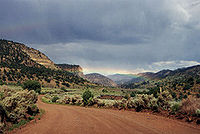
Minnie Maud is the name of a creek and canyon in eastern Utah that is noted as the western starting point of the Nine Mile Canyon petroglyphs section. Minnie Maud Creek is a stream whose headwaters begin where the Western Tavaputs and Wasatch Plateau meet the Uinta Mountains.[1]
The creek flows through a comparatively narrow valley and has limited irrigation possibilities. It has a general easterly course and merges with Nine Mile Creek. Minnie Maud Creek drains into Nine Mile Creek which reaches the Green River in Desolation Canyon.[2]
Minnie Maud Canyon which is formed by Minnie Maud Creek is relatively narrow and lacks Fremont Cultural ruins and writings that are abundant in Nine Mile Canyon. Due to its narrow nature, Minnie Maud Canyon was never permanently settled, although a school district that served residents in Nine Mile Canyon was briefly opened in the canyon in 1896 and took the name Minnie Maud. Minnie Maud School District lacked the necessary funds and closed in 1898 with only 43 students.[3] The source of the name Minnie Maud remains a mystery, but most traditional accounts say that it was named after two girls Minnie and Maud who lived in Nine Mile Canyon.[4]
References
- ^ Report on the lands of the arid region of the United States: with a more detailed account of the lands of Utah: with maps. Authors John Wesley Powell, et al. Edition 2 Publisher Government Printing Office, 1879
- ^ Water-supply paper, Issues, 279-281, Geological Survey (U.S.) Publisher G.P.O., 1916
- ^ Public documents: state of Utah. John R. Park, Superintendent of Public Education. Published 1899
- ^ A Brief History of Carbon County by the Teachers, Pupils, and Patrons of Carbon District. Lamont Poulter 1930
External links
Categories:- Canyons and gorges of Utah
- Landforms of Carbon County, Utah
- Rivers of Utah
Wikimedia Foundation. 2010.

