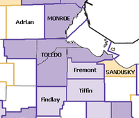
- Toledo, Ohio metropolitan area
-
Toledo-Fremont
Common name: Metro ToledoLargest city Toledo Other cities - Perrysburg
- Fremont
- Bowling Green
- AdrianPopulation Ranked 79th in the U.S. - Total 651,429 - Density 402/sq. mi.
155/km²Area 1,619 sq. mi.
4,193 km²State(s) Ohio Elevation - Highest point Unknown feet (Unknown m) - Lowest point Unknown feet (Unknown m) The Toledo Metropolitan Area is a metropolitan area centered in the American city of Toledo, Ohio. As of the 2010 census, the MSA had a population of 651,429.
According to the U.S. Census Bureau, the metropolitan area includes the counties of Fulton, Lucas, Ottawa and Wood. The Toledo broadcast media market includes outlying counties and serves approximately one million residents. The Toledo metro area has strong economic ties to the nearby Detroit-Windsor area within an hour drive and it's 6 million residents straddling the US and Canada border. Toledo is part of the Great Lakes Megalopolis which has an estimated 54 million residents in the region.
The separate urban area of Fremont, Ohio, which has strong commuter interchange with the Toledo metropolitan area, is included in a wider labor market area called the Toledo-Fremont Combined Statistical Area. A wider definition may add the Sandusky Metropolitan Area, although the US Census considers them separate MSAs. Other extended additions may include the Monroe, Michigan MSA, the micropolitan areas of Findlay, Tiffin, and Adrian, Michigan, as well as Henry County in Ohio. Although a separate broadcast media market,the Toledo Metro area and Metro Detroit, share common cultural aspects, situated on the Great Lakes.
Contents
Regional education
There are several higher education institutions that operate campuses in and near the city of Toledo and its metropolitan area. Some of the larger populated universities and colleges include the University of Toledo, Davis College, Lourdes College, University of Toledo Medical Center, Mercy College of Northwest Ohio, Stautzenberger College, Toledo Academy of Beauty, Toledo Professional Skills Institute, Owens Community College, University of Findlay, Bowling Green State University, Terra Community College, Adrian College, The University of Michigan in nearby Ann Arbor and also several other smaller institutes.
Population
Largest places in the Toledo Area[1] City 2005 2000 2010 Toledo 301,285 313,619 287,128 Sylvania Township 45,160 44,253 Findlay 39,118 38,967 Bowling Green 29,793 29,636 Bedford Township, MI 31,126 28,606 Springfield TWP 24,791 24,123 Monroe, MI 21,796 22,076 Adrian, MI 21,784 21,574 Frenchtown Township, MI 21,056 20,777 Oregon 19,175 19,355 Fremont 17,049 17,375 Perrysburg 16,980 16,945 Maumee 14,285 15,237 Monroe Charter Township, MI 14,077 13,491 Perrysburg Township 13,634 13,613 Fostoria 13,395 13,931 Lake Township 10,442 10,350 Napoleon Township 10,224 10,331 Waterville Township 10,136 9,469 The Toledo Metropolitan Area is the sixth largest metropolitan area in the state of Ohio. The other five are Greater Cleveland, Metro Columbus, Cincinnati Metropolitan Area, Greater Dayton (Miami Valley), and Akron.
All communities and townships
Fulton County
Communities
Townships
Lucas County
Communities
Townships
Ottawa County
Communities
Townships
Wood County
Communities
Townships
Demographics
As of the census[1] of 2010, there were 659,188 people, 259,973 households, and 169,384 families residing within the MSA. The racial makeup of the MSA was 83.03% White, 12.01% African American, 0.25% Native American, 1.07% Asian, 0.02% Pacific Islander, 1.79% from other races, and 1.83% from two or more races. Hispanic or Latino of any race were 4.35% of the population.
The median income for a household in the MSA was $42,686, and the median income for a family was $51,882. Males had a median income of $38,959 versus $25,738 for females. The per capita income for the MSA was $20,694.
References
- ^ "American FactFinder". United States Census Bureau. http://factfinder.census.gov. Retrieved 2008-01-31.
External links
 State of Ohio
Columbus (capital) Topics History · Geography · People · Government · Elections · Delegations · Economy · Demographics · Education · Colleges and universities · Visitor Attractions · Portal
Regions Allegheny Plateau · Appalachian Ohio · Black Swamp · The Bluegrass · Extreme Northwest Ohio · Glacial till plains · Lake Erie · Lake Erie Islands · Miami Valley · Northwest Ohio · Western Reserve
Metro areas Akron · Canton-Massillon · Cincinnati · Cleveland · Columbus · Dayton · Findlay-Tiffin · Ironton · Lima · Mansfield · Steubenville · Toledo · Youngstown-Warren
Largest cities Akron · Canton · Cincinnati · Cleveland · Cleveland Heights · Columbus · Cuyahoga Falls · Dayton · Elyria · Euclid · Hamilton · Kettering · Lakewood · Lorain · Massillon · Mansfield · Middletown · Newark · Parma · Springfield · Toledo · Youngstown Wooster ·
Counties Adams · Allen · Ashland · Ashtabula · Athens · Auglaize · Belmont · Brown · Butler · Carroll · Champaign · Clark · Clermont · Clinton · Columbiana · Coshocton · Crawford · Cuyahoga · Darke · Defiance · Delaware · Erie · Fairfield · Fayette · Franklin · Fulton · Gallia · Geauga · Greene · Guernsey · Hamilton · Hancock · Hardin · Harrison · Henry · Highland · Hocking · Holmes · Huron · Jackson · Jefferson · Knox · Lake · Lawrence · Licking · Logan · Lorain · Lucas · Madison · Mahoning · Marion · Medina · Meigs · Mercer · Miami · Monroe · Montgomery · Morgan · Morrow · Muskingum · Noble · Ottawa · Paulding · Perry · Pickaway · Pike · Portage · Preble · Putnam · Richland · Ross · Sandusky · Scioto · Seneca · Shelby · Stark · Summit · Trumbull · Tuscarawas · Union · Van Wert · Vinton · Warren · Washington · Wayne · Williams · Wood · Wyandot
Wikimedia Foundation. 2010.

