- Meares, California
-
Meares — Unincorporated community — Location in California
 Meares
Coordinates: 41°37′15″N 121°11′56″W / 41.62083°N 121.19889°WCoordinates: 41°37′15″N 121°11′56″W / 41.62083°N 121.19889°W Country United States State California County Modoc County Elevation[1] 4,423 ft (1,348 m) Meares is an unincorporated community in Modoc County, California.[1] It is located 6.25 miles (10 km) northwest of Hackamore,[2] at an elevation of 4423 feet (1348 m).[1]
References
Municipalities and communities of Modoc County, California County seat: Alturas City 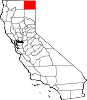
CDPs Adin | California Pines | Canby | Cedarville | Daphnedale Park | Eagleville | Fort Bidwell | Lake City | Likely | Lookout | New Pine Creek | Newell
Unincorporated
communitiesAmbrose | Boles | Bormister | Brooks Mill | Campbell | Cantrall Mill | Christensen | Copic | Cornell | D Flourney | Dalton | Davis Creek | Day | Demuth | Derner | Dibble Place | Fairport | Fletcher Place | Flourney | Grizzlie Place | Hackamore | Hannchen | Harper | Homestead | Juniper | K Flourney | Kalina | Kandra | Kauffman | Kephart | Lakeview Junction | Liskey | Lookout Junction | Mammoth | McArthur | McGarva | Meares | Menlo Baths | Mulkey Place | Old Hulbert Place | Perez | R Flourney | Ramsey | Scarface | Staley | Stronghold | Surprise Station | Tionesta | Tuber | Vestil | White Horse | Williams | Willow Ranch
Indian
reservationsAlturas Indian Rancheria | Fort Bidwell Reservation | XL Rancheria
Former
settlementsCategories:- Populated places in Modoc County, California
- Unincorporated communities in California
- Modoc County, California geography stubs


Wikimedia Foundation. 2010.