McKeldin Square

McKeldin Square
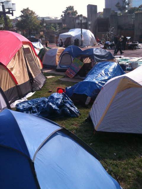
Occupy Baltimore protesters at McKeldin Square

McKeldin Square is an area of Downtown Baltimore, located near the Inner Harbor at the corners of Pratt and Light Streets.

The square, with its fountain, serves as a gateway to the Inner Harbor.[1][2]

McKeldin Square has been designated as Baltimore's zone for protests, where it is legal to excercise one's First Amendment rights and pass out pamphlets.[3] Permits are required for groups with groups of 25 or more requiring a permit. On October 4, 2011, it became the location of the Occupy Baltimore protests.

References

  1. ^ Wylson, Anthony (1986). Aquatecture: architecture and water. Architectural Press. p. 63. 
  2. ^ Snedcof, Harold R. (1985). Cultural facilities in mixed-use development. Urban Land Institute. p. 236. 
  3. ^ Walker, Andrea K. (September 18, 2011). "Spray-paint artist arrested at Inner Harbor". The Baltimore Sun. http://articles.baltimoresun.com/2011-09-18/news/bs-md-oc-artist-arrested-20110918_1_ocean-city-paint-spray. Retrieved 17 November 2011. 

Wikimedia Foundation. 2010.

Игры ⚽ Поможем написать реферат

Look at other dictionaries:

  • Occupy Baltimore — Part of the Occupy protests Tents erected at McKeldin Square Date October 4, 2011 …   Wikipedia

  • Occupy Wall Street — Die Demonstration am 30. September 2011 …   Deutsch Wikipedia

  • University of Maryland, College Park — University of Maryland redirects here. For other uses, see University of Maryland (disambiguation). Coordinates: 38°59′15.0″N 76°56′24.0″W / 38.9875°N 76.94°W …   Wikipedia

  • Interstate 695 (Maryland) — Interstate 695 Baltimore Beltway Route information …   Wikipedia

  • Baltimore County, Maryland — Infobox U.S. County county = Baltimore County state = Maryland founded year = 1659 seat wl = Towson area total sq mi =682 area land sq mi =599 area water sq mi =83 area percentage = 12.23% census estimate yr = 2005 pop = 786113 density km2 =487… …   Wikipedia

  • Maryland Terrapins football — Current season …   Wikipedia

  • Anne Arundel County, Maryland — Infobox U.S. County county = Anne Arundel County state = Maryland map size = 225 founded year = 1650 seat wl = Annapolis | largest city wl = Glen Burnie leader = Janet S. Owens area total sq mi =588 area land sq mi =416 area water sq mi =172 area …   Wikipedia

  • Hecht's — Infobox Defunct Company company name = Hecht s company fate = Renamed Macy s successor = Macy s foundation = 1857 defunct = 2006 location = Arlington, Virginia industry = Retail key people = products = Clothing, footwear, bedding, furniture,… …   Wikipedia

  • College Park, Maryland — College Park, MD   City   Seal …   Wikipedia

  • The Mall at Prince Georges — infobox shopping mall shopping mall name = The Mall at Prince Georges image width = 250 caption = location = opening date = owner= manager= Pennsylvania Real Estate Investment Trust developer= number of stores = number of anchors = floor area =… …   Wikipedia

Share the article and excerpts

Direct link
Do a right-click on the link above
and select “Copy Link”