- Matachewan dike swarm
-
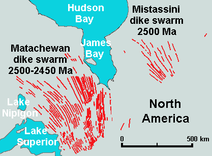
 Map of the Matachewan and Mistassini dike swarms of Eastern Canada
The Matachewan dike swarm is a large 2,500 to 2,450 million year old Paleoproterozoic dike swarm of Northern Ontario, Canada. It consists of basaltic dikes that were intruded in greenschist, granite-greenstone, and metamorphosed sedimentary terrains of the Superior craton of the Canadian Shield.[1] With an area of 360,000 km2 (140,000 sq mi), the Mistassini dike swarm stands as a large igneous province.[2]
See also
- Matachewan hotspot
- Volcanism of Canada
- Volcanism of Eastern Canada
References
Large igneous provinces Brazilian Highlands · Caribbean · Central Atlantic · Circum–Superior · Columbia River · Deccan · Emeishan · Ethiopian Highlands · Franklin (Franklin dike swarm) · High Arctic (Sverdrup Basin) · Karoo-Ferrar · Kerguelen · Marathon · Keweenawan · Long Range · Mackenzie (Coppermine River · Mackenzie dike swarm) · Matachewan · Mistassini · North Atlantic · Ontong Java-Manihiki-Hikurangi · Paraná and Etendeka · Siberian · Ungava · WinagamiCategories:- Dike swarms
- Volcanism of Ontario
- Paleoproterozoic volcanism
- Volcanology stubs
Wikimedia Foundation. 2010.