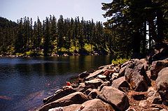
- Mason Lake (King County)
-
Mason Lake 
Location King County, Washington, USA, near Snoqualmie Pass Coordinates 47°25′31.29″N 121°33′8.76″W / 47.4253583°N 121.5524333°WCoordinates: 47°25′31.29″N 121°33′8.76″W / 47.4253583°N 121.5524333°W Basin countries United States Surface elevation 4,183 ft (1,275 m) Islands none Mason Lake is a naturally occurring mountain lake located between Mount Defiance and Bandera Mountain near Snoqualmie Pass, King County, Washington.[1] Accessible only by hike via the 3.4 mile-long Mason Lake Trail (also known as "Ira Spring Memorial Trail"), Mason Lake is at an elevation of 4,200 feet[2]
Directions to Mason Lake Trail
Coming East on I-90, take Exit 45 (USFS Road 9030) and turn left off the exit onto FS Road 9031. This road is not paved, but is in good enough condition to support sedans and small cars. After about 1 mile of uphill switchbacks with great views of the surrounding mountains, the road splits; take the left fork (the right one, which is also steeper, ends at a rock quarry). After another 2 miles of uphill driving, the road opens up into a parking lot for the Mason Lake Trail (Ira Springs Memorial Trail) and Bandera Mountain Trail. Note: hiking/parking passes required.
References
- ^ "Mason Lake" Trimble Outdoors, http://www.trimbleoutdoors.com/ViewTrip.aspx?TripID=8376
- ^ Sykes, Karen. "Hike of the Week: New trail is a hiker-friendly gem" http://www.seattlepi.com/getaways/138951_hike11.html
Categories:- Landforms of King County, Washington
- Lakes of Washington (state)
Wikimedia Foundation. 2010.

