Mary Avenue Bridge

Mary Avenue Bridge
Mary Avenue Bridge
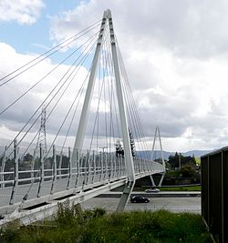
Carries bicycles and pedestrians
Crosses Interstate 280 (California)
Locale Cupertino, California
Design Cable-stayed bridge
Construction end 2008-11-17
Opened 2009-04-30[1]
Coordinates 37°20′0.2″N 122°3′2″W / 37.333389°N 122.05056°W / 37.333389; -122.05056 (Mary Avenue Bridge)Coordinates: 37°20′0.2″N 122°3′2″W / 37.333389°N 122.05056°W / 37.333389; -122.05056 (Mary Avenue Bridge)
Mary Avenue Bridge is located in California

The Mary Avenue Bridge is a cable-stayed bridge over Interstate 280 (California) in Cupertino, California carrying bicycle and pedestrian traffic. North of I-280, Mary Avenue ends as a parking lot and drop-off area for Homestead High School. Bicyclists and pedestrians may cross I-280 using the bridge; Mary Avenue continues south of the highway.

At night the bridge is lit up and is a beautiful sight for those driving on or crossing Interstate 280.

External links

References


Wikimedia Foundation. 2010.

Игры ⚽ Нужна курсовая?

Look at other dictionaries:

  • 10th Avenue Bridge — Infobox Bridge bridge name=10th Avenue Bridge caption=The 10th Avenue Bridge in Minneapolis official name= crosses=Mississippi River carries=Two lanes of automobile traffic locale=Minneapolis, Minnesota design=Concrete rib deck arch bridge… …   Wikipedia

  • Tenth Avenue Bridge — 44.978888888889 93.243888888889 Koordinaten: 44° 58′ 44″ N, 93° 14′ 38″ W f1 …   Deutsch Wikipedia

  • Lowry Avenue Bridge — Infobox Bridge bridge name=Lowry Avenue Bridge caption=A view from the west bank of the Mississippi, just south of the bridge, showing four of the five truss spans. official name= crosses=Mississippi River carries=Two lanes of CSAH 153 (Lowry… …   Wikipedia

  • Hennepin Avenue Bridge — Infobox Bridge bridge name=Hennepin Avenue Bridge caption=Hennepin Avenue Bridge as it appears today. official name= crosses=Mississippi River carries=6 lanes of Hennepin Avenue (CSAH 52) locale=Minneapolis, Minnesota design=Suspension bridge… …   Wikipedia

  • Plymouth Avenue Bridge — Infobox Bridge bridge name=Plymouth Avenue Bridge caption= official name= crosses=Mississippi River carries=Four lanes of Plymouth Avenue locale=Minneapolis, Minnesota design=Four span segmental bridge mainspan=140 feet length=943 feet width=55… …   Wikipedia

  • Hennepin Avenue Bridge — 44.985277777778 93.263888888889 Koordinaten: 44° 59′ 7″ N, 93° 15′ 50″ W f1 …   Deutsch Wikipedia

  • Broadway Avenue Bridge — Infobox Bridge bridge name=Broadway Avenue Bridge caption= official name=Broadway Avenue Bridge crosses=Mississippi River carries=Four lanes of West Broadway/Broadway Street Northeast locale=Minneapolis, Minnesota design=Girder bridge… …   Wikipedia

  • Parrish Avenue Bridge — Infobox Bridge bridge name=Parrish Avenue Bridge caption= official name= crosses=Mississippi River carries=Two lanes of County Road 42 locale=Elk River, Minnesota design=Concrete girder bridge mainspan=112 feet length=450 feet width=46 feet below …   Wikipedia

  • Queen Avenue Bridge — Infobox nrhp | name =Queen Avenue Bridge nrhp type = caption = The southwest side of the bridge with the sheds underneath used for the Minnesota Streetcar Museum cars location= Minneapolis, Minnesota lat degrees = 44 lat minutes = 55 lat seconds …   Wikipedia

  • Washington Avenue Bridge (Minneapolis) — Infobox Bridge bridge name=Washington Avenue Bridge caption=The Washington Avenue Bridge in Minneapolis, looking south from NP Bridge #9 official name= crosses=Mississippi River carries=Four lanes of County Road 122 on the lower deck, bicycles… …   Wikipedia

Share the article and excerpts

Direct link
Do a right-click on the link above
and select “Copy Link”