- Marindia
-
Marindia — Resort of the Costa de Oro — Location in Uruguay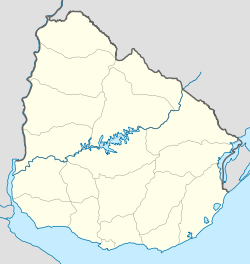
 Marindia
Coordinates: 34°46′15″S 55°49′25″W / 34.77083°S 55.82361°WCoordinates: 34°46′15″S 55°49′25″W / 34.77083°S 55.82361°W Country  Uruguay
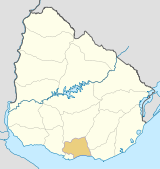
Department Canelones Department Population (2004) - Total 2,586 Time zone UTC -3 Postal code 15104 Area code(s) +598 437 Marindia is a resort of the Costa de Oro in the Canelones Department of southern Uruguay. It is located on the Ruta Interbalnearia between the resorts Salinas to its west and Fortín de Santa Rosa to its east.
Population
In 2004 it had a population of 2,586.[1]
Year Population 1963 115 1975 360 1985 626 1996 1,493 2004 2,586 Source: Instituto Nacional de Estadística de Uruguay[2]
References
- ^ "2004 Census of Canelones department" (XLS). INE. 2004. http://www.ine.gub.uy/fase1new/Canelones/Cuadro7_03.XLS. Retrieved 3 July 2011.
- ^ "1963–1996 Statistics / M" (DOC). Instituto Nacional de Estadística de Uruguay. 2004. http://www.ine.gub.uy/biblioteca/toponimico/TOPOletraM.doc. Retrieved 3 July 2011.
External links
 Costa de Oro
Neptunia • Pinamar-Pinepark • Salinas • Marindia • Fortín de Santa Rosa • Villa Argentina • Atlántida • Las Toscas • Parque del Plata • Las Vegas • La Floresta • Costa Azul • Bello Horizonte • Guazuvirá Nuevo • Guazú-Virá • San Luis • Los Titanes • La Tuna • Araminda • Santa Lucía del Este • Biarritz • Cuchilla Alta • El Galeón • Santa Ana • Argentino • Jaureguiberry
Canelones Department of UruguayCapital: Canelones Towns and
villagesAguas Corrientes • Atlántida • Barrio Cópola • Barrio La Lucha • Barros Blancos • Canelones • Castellanos • Cerrillos • City Golf • Ciudad de la Costa • Colonia Nicolich • Costa Azul • Costa y Guillamón • Dr. Francisco Soca • Empalme Olmos • Estación Atlántida • Estanque de Pando • Jardines de Pando • Joaquín Suárez • Juanicó • La Floresta • La Paz • Las Piedras • Las Toscas • Marindia • Migues • Montes • Neptunia • Pando • Parque del Plata • Progreso • Salinas • San Antonio • San Bautista • San Jacinto • San Luis • San Ramón • Santa Lucía • Santa Rosa • Sauce • Seis Hermanos • Tala • Toledo • Totoral del Sauce • Villa Aeroparque • Villa Argentina • Villa Crespo y San Andrés • Villa El Tato • Villa Felicidad • Villa San José
Resorts of the
Ciudad de la CostaEl Pinar • Lomas de Solymar • Solymar • Parque Carrasco • Lagomar • San José de Carrasco • Barra de Carrasco • Shangrilá • Colinas de Solymar • El Bosque
Sights Bridge of the Americas • Carrasco Airport • Lago Calcagno • Parque Roosevelt • Costa de Oro • El Águila • Iglesia Atlántida • Hotel Planeta Palace • Paso de las Toscas
Categories:- Uruguay geography stubs
- Populated places in the Canelones Department


Wikimedia Foundation. 2010.