- Ciudad de la Costa
-
Ciudad de la Costa — City — Location in Uruguay Coordinates: 34°49′0″S 55°57′0″W / 34.816667°S 55.95°WCoordinates: 34°49′0″S 55°57′0″W / 34.816667°S 55.95°W Country  Uruguay
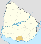
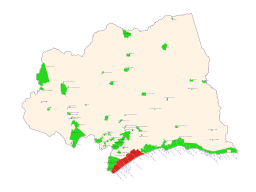
Department Canelones Department Founded 1994 Population (2004) - Total 83,888 Time zone UTC -3 Postal codes 15000 - 15008 Area code(s) +598 2 (+7 digits) Ciudad de la Costa is a city in Canelones Department of Uruguay, on the banks of the Río de la Plata between the streams Arroyo Carrasco and Arroyo Pando. It is considered an extension of the metropolitan area of Montevideo which it borders to the west, while to the east it borders Costa de Oro. It was declared a city on 19 October 1994 and given its current name.[1] Its population growth has placed it as the third most populated city of Uruguay as of 2004.
Contents
History
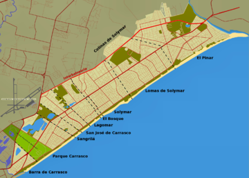
The area, characterized by a sandy beach 16 km long, was known as "Rincón de Carrasco" during the 19th century. It was populated gradually during the 20th century, forming a series of resorts starting from Barra de Carrasco in the west, up to El Pinar in the east. The various resorts became characterized by a high floating population that inhabited the area only in summer or on weekends, while most of the permanent population worked in Montevideo.
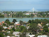
The abundance of sandy soils made possible the existence of multiple sand pits, which gave rise to the various lakes that characterize the area. Some lakes are used for bathing and water sports, while others are not suitable for these applications and, instead, act as a refuge for many species of birds and animals.
Since the 1980's there was an explosive growth of population due to an expansive process of Montevideo. According to the census of 1996, its population reached 66,402 inhabitants, 92.6% more than in 1985. The various resorts began to merge to form a unit that actually led to its declaration as a city. The growth in subsequent years has continued at a slower pace. According to the census of 2004, the population was of 83,888 inhabitants (28.8% more than in 1996).[2] The coastal city is the largest satellite town of the metropolitan area and the third largest city in Uruguay.
The population growth has not been accompanied by an adequate development of infrastructure services, so that much of the city lacks public sanitation and many roads are often impassable during rainy periods. Despite these difficulties, the Ciudad de la Costa is now a commercial and tourist centre of importance in the country. The Carrasco International Airport is located north of the city, and Autodromo Victor Borrat Fabini to the east.
Coastal resorts of Ciudad de la Costa
Population of the resorts according to 2004 census.[3]
Resort Post code Population El Pinar 15008 17,221 Lomas de Solymar 15006-7 16,018 Solymar 15005 15,908 Parque Carrasco 15000 8,476 Lagomar 15000 7,798 San José de Carrasco 15002 6,886 Barra de Carrasco 15000 4,747 Shangrilá 15001 2,902 Colinas de Solymar 15006-7 2,502 El Bosque 15004 941 The area of Lomas de Solymar also contains Parque de Solymar, Montes de Solymar and Médanos de Solymar. Postal code 15007 has been assigned to "Médanos de Solymar".
See also
References
- ^ Law 16610 "LEY N° 16.610". República Oriental del Uruguay, Poder Legislativo. 1994. http://www.parlamento.gub.uy/leyes/AccesoTextoLey.asp?Ley=16610&Anchor= Law 16610. Retrieved 27 June 2011.
- ^ "INE Censo Fase I - 2004 (see p. 36 of 63)" (PDF). INE. 2004. http://www.ine.gub.uy/fase1new/canelones/canelones_pres.pdf. Retrieved 27 June 2011.
- ^ "2004 Census of Canelones department" (XLS). INE. 2004. http://www.ine.gub.uy/fase1new/Canelones/Cuadro7_03.XLS. Retrieved 27 June 2011.
External links
- INE maps of Ciudad de la Costa resorts: Barra de Carrasco, Parque Carrasco, Shangrilá, San José de Carrasco, Lagomar, El Bosque, Solymar, Colinas de Solymar, Lomas de Solymar. El Pinae
 Ciudad de la Costa
Barra de Carrasco • Colinas de Solymar • El Bosque • El Pinar • Lagomar • Lomas de Solymar • Parque Carrasco • San José de Carrasco • Shangrilá • Solymar
 Canelones Department of Uruguay
Capital: Canelones Towns and
villagesAguas Corrientes • Atlántida • Barrio Cópola • Barrio La Lucha • Barros Blancos • Canelones • Castellanos • Cerrillos • City Golf • Ciudad de la Costa • Colonia Nicolich • Costa Azul • Costa y Guillamón • Dr. Francisco Soca • Empalme Olmos • Estación Atlántida • Estanque de Pando • Jardines de Pando • Joaquín Suárez • Juanicó • La Floresta • La Paz • Las Piedras • Las Toscas • Marindia • Migues • Montes • Neptunia • Pando • Parque del Plata • Progreso • Salinas • San Antonio • San Bautista • San Jacinto • San Luis • San Ramón • Santa Lucía • Santa Rosa • Sauce • Seis Hermanos • Tala • Toledo • Totoral del Sauce • Villa Aeroparque • Villa Argentina • Villa Crespo y San Andrés • Villa El Tato • Villa Felicidad • Villa San José

Resorts of the
Ciudad de la CostaEl Pinar • Lomas de Solymar • Solymar • Parque Carrasco • Lagomar • San José de Carrasco • Barra de Carrasco • Shangrilá • Colinas de Solymar • El Bosque
Sights Bridge of the Americas • Carrasco Airport • Lago Calcagno • Parque Roosevelt • Costa de Oro • El Águila • Iglesia Atlántida • Hotel Planeta Palace • Paso de las Toscas
Categories:- Uruguay geography stubs
- Populated places in the Canelones Department
- Ciudad de la Costa
Wikimedia Foundation. 2010.


