- Manuel Junction
-
Manuel Manuel Junction Location Place Near Whitecross Area Falkirk (council area) Coordinates 55°58′39″N 3°39′22″W / 55.9776°N 3.6562°WCoordinates: 55°58′39″N 3°39′22″W / 55.9776°N 3.6562°W Operations Original company Edinburgh and Glasgow Railway /
Slamannan and Borrowstounness RailwayPre-grouping North British Railway Post-grouping LNER Operated by Scottish Railway Preservation Society Platforms Historic - 3 (2 Upper, 1 Lower), Preservation - 0 History 21 February 1842 Bo'ness Junction (high level) opened on E&GR[1] 10 June 1856 Manuel (low level) opened on S&BR (Monkland Railways)[2] January 1866 High level station renamed Manuel[1][2] Unknown High level station renamed Manuel High Level; Low Level station rename Manuel Low Level[2] 1 May 1933 Manuel Low Level closed[2] 6 March 1967 Manuel High Level closed[2] 1990 Track restored between Birkhill and Manuel by BR. 9 May 2010 Bo'ness and Kinneil Railway service extended to Manuel. Stations on heritage railways in the United Kingdom A B C D E F G H I J K L M N O P Q R S T U V W X Y Z Manuel Junction is a railway junction near the village of Whitecross, Falkirk, Scotland. It currently serves both as the terminus of the Bo'ness and Kinneil Railway (operated by the Scottish Railway Preservation Society (SRPS)) and as the connection between the Glasgow to Edinburgh via Falkirk Line and that railway. There is currently no platform at Manuel and passengers on the branch service must remain on the train while the locomotive runs round the train.
Contents
History
The junction is constructed on the site of the original Edinburgh and Glasgow Railway Bo'ness Junction station which was first opened on 21 February 1842.[1] The original station had two platforms on the E&G (upper) line. In 1856[2] a single platform was opened with the (lower) Slamannan and Borrowstounness Railway line, part of the Monkland Railways and connected to the Slamannan Railway. Trains going from Bo'ness to the E&GR (westbound) used a steeply graded curve which the modern trackbed shares which rose from the north-facing Bo'ness Low Junction up to the west-facing Bo'ness High Junction.[3] To the west of the Bo'ness High Junction was the east-facing Coatbridge Line Junction[3] which allowed trains from the Linlithgow direction to head southbound on the Monkland Railways.
The low-level station was closed in 1933.[2] The upper station at Manuel survived until 1967[2] at which time the branch was cut back to Kinneil Colliery.
Preceding station Historical railways Following station Causewayend North British Railway
Kinneil Linlithgow North British Railway
Polmont  Heritage railways
Terminus Bo'ness and Kinneil Railway Birkhill Preservation
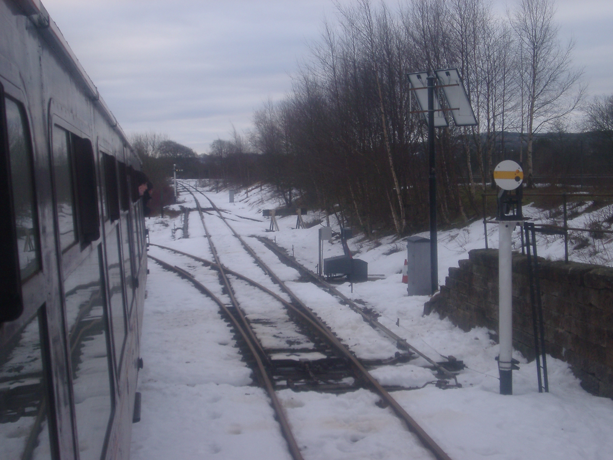
 A view of the track layout controlled by Manuel Link Ground Frame leading to the mainline
The line to the junction was relaid in 1990 by British Rail with funding from Tesco PLC so that SRPS Railtours could relocate their base of operations and coaching stock to Bo'ness from its previous base at Perth which was too crowded. The current junction with Network Rail is east-facing.
Layout
Manuel's track layout features a long curving loop with a short headshunt at the west end. The link-line leaves the loop 13 BR MK1 coach lengths from the end of the headshunt. A small trap point is located some way up the link line and further up, a gate, signifying the edge of the SRPS's ground. On the approach to Manuel, a fixed distant signal is encountered shortly before the line curves and climbs steeply up to the junction itself. The points at the north-west end of the loop are controlled by a 3-lever ground frame known as Manuel North. The east-facing link line is controlled by a 5-lever ground frame which includes mechanical control of two signals: a raised yellow disc signal reads up the link line and up onto Network Rail and a small arm signal prevents moves onto the B&KR. The points at the west end are hand points. Both ground frames are controlled by the train staff using Annett's locks and all signals are tubular upper quadrant in design. The points at the Network Rail end of the link-line are controlled from a ground frame released from Polmont signal box.
References
Notes
Sources
- Butt, R. V. J. (1995). The Directory of Railway Stations: details every public and private passenger station, halt, platform and stopping place, past and present (1st ed.). Sparkford: Patrick Stephens Ltd. ISBN 1-8526-0508-1. OCLC 60251199.
- Jowett, Alan (March 1989). Jowett's Railway Atlas of Great Britain and Ireland: From Pre-Grouping to the Present Day (1st ed.). Sparkford: Patrick Stephens Ltd. ISBN 1-8526-0086-1. OCLC 22311137.
- Yonge, John (May 1987). Gerald Jacobs. ed. British Rail Track Diagams - Book 1: ScotRail (1st edition ed.). Exeter: Quail Map Company. ISBN 0-9006-0948-6.
- Yonge, John (February 1993). Gerald Jacobs. ed. Railway Track Diagams - Book 1: Scotland and the Isle of Man (2nd edition ed.). Exeter: Quail Map Company. ISBN 0-9006-0995-8.
- Yonge, John (April 1996). Gerald Jacobs. ed. Railway Track Diagams - Book 1: Scotland and the Isle of Man (3rd edition ed.). Exeter: Quail Map Company. ISBN 1-8983-1919-7.
- Yonge, John (2007). Gerald Jacobs. ed. Railway Track Diagams - Book 1: Scotland & Isle of Man (Quail Track Plans) (fifth edition ed.). Bradford on Avon: "Trackmaps (formerly Quail Map Co)". http://www.trackmaps.co.uk.. ISBN 978-0-9549866-3-6. OCLC 79435248.
External links
- "Scottish Railway Preservation Society". http://www.srps.org.uk.
- "Google Maps view of Junction". http://maps.google.co.uk/maps?f=q&source=s_q&hl=en&geocode=&q=linlithgow&aq=&sll=53.800651,-4.064941&sspn=14.044769,39.506836&ie=UTF8&hq=&hnear=Linlithgow,+United+Kingdom&ll=55.976079,-3.654048&spn=0.006483,0.01929&t=h&z=16. Retrieved 21 January 2011.
- "Manuel Upper railway station on navigable OS map (1947)". http://www.npemap.org.uk/tiles/map.html#296,676,1. Retrieved 21 January 2011.
Categories:- Heritage railways in Scotland
- British railway junctions
- Railway stations opened in 1842
- Railway stations opened in 1856
- Railway stations closed in 1933
- Railway stations closed in 1967
- Disused railway stations in Falkirk
- Beeching closures in Scotland
- Former North British Railway stations
Wikimedia Foundation. 2010.