- Maniguin Island Lighthouse
-
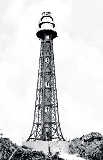
Maniguin Island Lighthouse 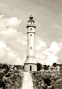

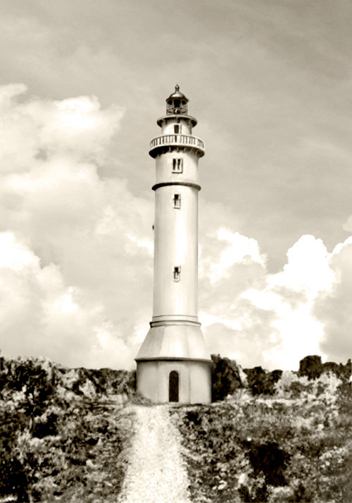
Location Culasi, Antique, Philippines Coordinates 11°35′52.58″N 121°41′48.21″E / 11.5979389°N 121.696725°E Year first constructed 1904 Year first lit 1906 Construction Reinforced concrete Tower shape Cylindrical Markings / pattern Grey tower Height 97 feet (29.6m) [1] Focal height 191 feet (58.2 m) [1] Original lens Fourth-order Fresnel Range 20 miles (32 Km) Characteristic Inactive Admiralty number F2288 NGA number 14500 ARLHS number PHI-091 The Maniguin Island Lighthouse is a lighthouse that marks the Cuyo East Passage, a main shipping route south into the Sulu Sea.[2] The island, also known as Maningning Island or Hammerhead Island,[3] is located 26.5 miles (42.6 km) off of the coast of Culasi, Antique in the Philippines. It has a narrow ridge 110 feet high across its southern end, and the remainder of the island is low and wooded, and not more than 15 feet high. It is fringed with coral reefs with deep water at their edges. The round cylindrical concrete tower with a gallery on top is located near the southeastern point of the island.[4]
Contents
History
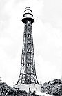
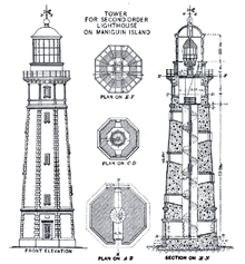 Original Spanish design for the Maniguin Lighthouse
The Spanish Plan for the Station
The Spanish Government's plan of building a second-order lighthouse on Maniguin Island was part of the Maritime Lighting program of the Philippine Archipelago which was in full swing in the latter part of 19th century.[5] The original design was a beautiful and massive masonry tower similar to the Cape Melville Lighthouse.
When the Americans took control of the Philippines after the Spanish-American War, the Spanish plans and records for all lighthouses were turned over to the United States. New, more economical plans were adopted to illuminate the islands as quickly as possible from the limited insular funds available, and the Spanish plans were scrapped.[6]
Construction of the Lighthouse
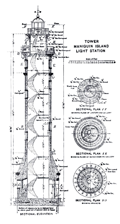
In 1904, a preliminary examination was made of this island. A map has been made and the elevation of the site of the proposed station obtained. A new plan for the various structures to be erected was prepared.[7] For the first time, reinforced concrete will be used instead of masonry for a lighthouse tower in the Philippines. A budget of ₱60,000 was set for the construction.
A party of two Americans, one Spanish mason, and 40 Filipinos was organized in December 1904, and sent to this station, leaving Manila on December 29. On March 20, 1905, the party was increased to a total of 106 by the employment of local laborers. A dedicated sloop named Jervey was used in transporting laborers and water.
On April 1, 1905, a temporary fixed white light from a lens lantern was displayed from the highest point of Maniguin Island, at an elevation of 130 feet above mean high water. The light was visible all around the horizon, and in clear weather was visible at a distance of 13 miles.[8]
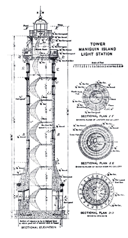 American design for the Maniguin Lighthouse, which was eventually constructed
Work on the tower was immediately begun after the construction of the temporary quarters. The dwellings and accessory buildings were also made with reinforced concrete. A contract had been let in Hong Kong for the iron stairs, which were delivered in August 1905.
On all previous stations, it has been necessary either to use materials purchased or plans prepared under the supervision of the Spanish Government. As this station was the first to be constructed throughout, construction was speedy and of higher standard at a much lower cost. At the end of the 1905, the tower was constructed to the balcony, cistern built, foundation of dwelling finished, doors, windows, and louvers made.[9]
Work was completed the following year and the fourth-order light was lit for the first time.
Current Condition
This American lighthouse was recently abandoned. The Philippine Coast Guard erected a new white tower powered by solar energy a short distance away from the original tower as a replacement.
See also
- Lighthouses in the Philippines
External links
- Image of the American-built Maniguin (Maningning) lighthouse and the white replacement tower.
- Lighthouse Depot: Maniguin Island Light
References
- ^ a b U.S. Hydrographic Office, "List of Lights, Vol.2", Washington Government Printing Office, 1920
- ^ Rowlett, Russ. "Lighthouses of Southern Philippines". The Lighthouse Directory. University of North Carolina at Chapel Hill. http://www.unc.edu/~rowlett/lighthouse/phls.htm. Retrieved 2010-05-03.
- ^ "Updates for Panay Explorers". http://www.panayexplorers.com/blog_1_1_2008.htm. Retrieved 2010-05-03.
- ^ Department of Commerce, "United States Coast Pilot, Philippine Islands", p.207. Washington Printing Office, 1919.
- ^ Por Algunos Padres de la Mision de la Compañia de Jesus en Estas Islas, "El Archipiélago Filipino, Collecion de Datos", p.527, Washington: Imprenta del Gobierno, 1900.
- ^ Spencer Cosby, "Transactions of the American Society of American Civil Engineers, Vol.LVIII: Lighthouse Construction in the Philippines, p.280. American Society of Civil Engineers, 1907
- ^ Bureau of Insular Affairs, War Department, "Fifth Annual Report of the Philippine Commission 1904, Part 3", p.150. Washington Government Printing Office, 1905
- ^ Department of Commerce and Labor, "Notice to Mariners, June 1905", p.16 Washington Government Printing Office, 1905
- ^ Bureau of Insular Affairs, U.S. War Department, "Sixth Annual Report of the Philippine Commission 1905, Part 3", Washington Government Printing Office, 1906
Coordinates: 11°35′52.58″N 121°41′48.21″E / 11.5979389°N 121.696725°E
 Apo Reef • Bagacay Point • Bagatao Island • Basco • Batag Island • Bugui Point • Caballo Island • Cabra Island • Cape Bojeador • Cape Bolinao • Cape Engaño • Cape Melville • Cape Santiago • Capitancillo Island • Capones Island • Capul Island • Corregidor Island • Jintotolo Island • Lusaran Point • Malabrigo Point • Maniguin Island • Pasig River • San Bernardino Island • Sibago Island • Siete Pecados Islands • Tanguingui Island
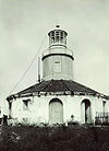 Categories:
- Lighthouses in the Philippines
- Buildings and structures completed in 1906


Wikimedia Foundation. 2010.