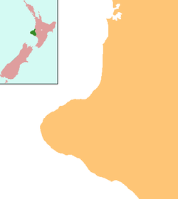
- Manaia, Taranaki
-
For other uses, see Manaia.
Manaia Coordinates: 39°33′3″S 174°7′30″E / 39.55083°S 174.125°E Country New Zealand Region Taranaki District South Taranaki District Population (2006) - Total 927 Manaia is a rural town in South Taranaki District, New Zealand. Opunake is 29 km to the northwest, and Hawera is 13 km to the southeast. Kaponga is 15 km north. State Highway 45 passes through the town.[1][2] Manaia is named after the former Māori chief of the district, Hukunui Manaia.
The Manaia and surrounding community has a South Taranaki District Council LibraryPlus, which provides a full library service and Council related services. These services include being able to register your dog, pay your rates or inquire about obtaining a building permit. Other services include a Tot Time for the under 5s, a regular crossword morning and bookclubs catering to both children and adults. The LibraryPlus also has numerous APN computers, offering free internet and Skype to the public.
The population was 927 in the 2006 Census, a decrease of 24 from 2001.[3]
History
Only a small town, Manaia has its history still visible with the Manaia Redoubt still present.
Built around 1880 on the site of a former pā (Te Takahe) during peacetime, this redoubt and wooden watchtower was created for the passive resistance of the Parihaka chief, Te Whiti o Rongomai, and his followers. The wooden watchtower (35 feet high) was blown down in a storm and replaced in 1912 by a concrete one still standing today amidst the 18-hole golf course surrounded by two original blockhouses. Also, trenches surround the tower and blockhouses. It could house 160 men and all the timber used for the construction was pit sawn locally by the constables.
The golf course is one of the oldest of Taranaki, created around 1905.
Also when driving into Manaia from Hawera the remains of the old flour mill can be seen on the left hand side.
These concrete remains of the mill were built in 1900 to replace the original wooden mill built in 1882 by Mr D. F. McVicar of the Sentry Hill flour mill, New Plymouth.
The local Waiokura River powered the mill by a 15-foot (4.6 m) water wheel which developed 15 horsepower (11 kW). The mill had 4 stories, and a 23-foot (7.0 m) stud. It was 35 feet (11 m) long and 20 feet (6.1 m) wide. About 40,000 feet (12,000 m) of timber was used and the building provided storage for about 15,000 sacks of flour.
Yarrows Family Bakers[4] employs around 250 people, and has been the main business in Manaia since 1923.[5] The company manufactures fresh and frozen breads and bakery products. Its clients include Foodstuffs, Subway, and Pams.[6] The company went into receivership in 2011.[7]
Manaia and surrounding districts enjoy a full library and council service. Manaia LibraryPlus is open Monday, Wednesday, Thursday, Friday from 8.30-5pm; and Tuesday 9.30-5pm.
In 2007, a 14 year old Jack Russell terrier called George died protecting 5 local children from an attack by two pit bull terriers. He was given a posthumous PDSA Gold Medal, the animal equivalent of the George Cross, at a special ceremony in Manaia in February 2009. The town has also erected a statue in his honour.[8]
Education
Manaia School is a coeducational full primary (years 1-8) school with a decile rating of 4 and a roll of 160.[9] The school was founded in 1882.[10] In 2005, Tokaora School closed and merged with Manaia School.[11]
Notes
- ^ Peter Dowling (editor) (2004), Reed New Zealand Atlas, Reed Books, map 34, ISBN 0-7900-0952-8
- ^ Roger Smith, GeographX (2005), The Geographic Atlas of New Zealand, Robbie Burton, map 96, ISBN 1-877333-20-4
- ^ Quickstats about Manaia, Taranaki
- ^ "About Yarrows". Yarrows Family Bakers. 2011. http://www.yarrows.co.nz/about.php.
- ^ McCloy, Nicola (2008). Made in New Zealand: Stories of iconic Kiwi brands. Auckland: Random House. pp. 36–37. ISBN 978-1-86979-018-9.
- ^ "Partners & Customers". Yarrows Family Bakers. 2011. http://www.yarrows.co.nz/a_partnersCustomers.php.
- ^ "Yarrow bakery placed in receivership". The New Zealand Herald. 31 May 2011. http://www.nzherald.co.nz/business/news/article.cfm?c_id=3&objectid=10729272. Retrieved 31 May 2011.
- ^ "Another award for heroic Jack Russell". Fairfax New Zealand. 11 February 2009. Archived from the original on 2009-02-12. http://www.webcitation.org/5eVz1Wp28).
- ^ "Te Kete Ipurangi - Manaia School". Ministry of Education. http://www.tki.org.nz/e/schools/display_school_info.php?school_id=2097.
- ^ "Manaia School". Hawera & Normanby Star. 26 June 1882. pp. 2. http://paperspast.natlib.govt.nz/cgi-bin/paperspast?a=d&d=HNS18820626.2.12.
- ^ "Mergers, Closures and New Schools, January 2005 - December 2005" (XLS). Education Counts. http://www.educationcounts.govt.nz/statistics/schooling/directories/?a=7772.
Categories:- Populated places in New Zealand
- South Taranaki District
Wikimedia Foundation. 2010.

