- Malapai Hill
-
Malapai Hill 
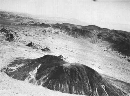
Oblique aerial view of Malapai Hill, looking eastElevation 4,278 feet (1,304 m)[1] NGVD 29[2] Prominence 360 ft (110 m) [2] Location Riverside County, California, USA

Coordinates 33°56′23″N 116°05′16″W / 33.9397315°N 116.0877801°WCoordinates: 33°56′23″N 116°05′16″W / 33.9397315°N 116.0877801°W[1] Topo map USGS Malapai Hill Malapai Hill is a small mountain in the middle of Joshua Tree National Park in southeastern California, which may have been part of an ancient volcano. It formed during a period of intrusive activity and either rose above the surface or eventually was exposed by erosion. Its name is a derivative of the Spanish word, malpaís.
Contents
Geography and geology
The peak rises in Joshua Tree National Park, west of the Hexie Mountains, north of the San Bernardino Mountains and near Queen Valley.[3] Formed by eruptive activity sometime between 8 million and 100,000 years ago, Malapai Hill is the product of the intrusion of magma, into White Tank monzogranite, that cooled as basalt. The exact origin of the landform is not known: it might have been part of an older volcanic complex, or it might have never penetrated the surface but cooled underground and then became exposed as the somewhat softer granite around it was eroded over time.[4]
There are two summits with the true summit rising on the north.[3] The volcanic features include piles of monzogranite and basalt talus on the mountain's steep slopes.[3]
The hill is composed of aphanitic alkaline olivine basalt, with phenocrysts of olivine. Xenoliths of lherzolite are abundant and more rarely of White Tank monzogranite. The lherzolite nodules are interpreted as representing depleted mantle from the area of partial melting that produced the magma.[5]
Etymology
Malapai is an Americanization of the Spanish word, malpaís, which can be translated as bad terrain.[6] The term malpias is widely used to refer to badlands characterized by eroded rocks of volcanic origin. The cactus and xeric scrub plant community surrounding the mountain is characteristic of the stark and dry desert here.[3]
Recreation
While there are not maintained trails in the area, the peak, which is in Joshua Tree Wilderness, is listed by the Angles Chapter of the Sierra Club as a recommended outing.[7] Magnetite formations near the summit are known to disrupt magnetic compasses.[3]
References
- ^ a b "Malapai Hill". Geographic Names Information System, U.S. Geological Survey. http://geonames.usgs.gov/pls/gnispublic/f?p=gnispq:3:::NO::P3_FID:1660977.
- ^ a b "Malapai Hill, California". Peakbagger.com. http://www.peakbagger.com/peak.aspx?pid=24159.
- ^ a b c d e Harris, David Money; Jennifer Money Harris (2009). Afoot & Afield Inland Empire: A Comprehensive Hiking Guide. Wilderness Press. p. 344. ISBN 0899974627.
- ^ Kaiser, James (2006). Joshua Tree: The Complete Guide: Joshua Tree National Park. self-published. p. 114.
- ^ Stull, R.J.; McMillan K. (197 3). "Origin of Lherzolite Inclusions in the Malapai Hill Basalt, Joshua Tree National Monument, California". Bulletin Geological Society of America 84 (7): 2343–2350. doi:10.1130/0016-7606(1973)84<2343:OOLIIT>2.0.CO;2.
- ^ Gudde, Erwin Gustav (1950). California Place Names. University of California Press. p. 222.
- ^ "The Great Lower Peaks List as of 2008". Angeles Chapter of the Sierra Club. http://angeles.sierraclub.org/lpc/lpclist.htm.
External links
Categories:- Volcanoes of California
- Landforms of Riverside County, California
- Malpaises
- Natural history of the Mojave Desert
- Volcanic plugs of California
- Joshua Tree National Park

Wikimedia Foundation. 2010.