- Maladeta
-
Maladeta 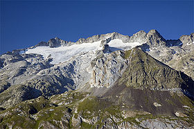
MaladetaElevation 3,312 m (10,866 ft) Listing List of mountains in Aragon Translation from "damned mountains" (Spanish) Location Location in the Pyrenees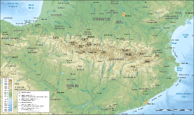
 Maladeta
Location Ribagorza,  Aragon
Range Pyrenees Coordinates 42°38′50″N 0°38′22″E / 42.64722°N 0.63944°ECoordinates: 42°38′50″N 0°38′22″E / 42.64722°N 0.63944°E Climbing First ascent 28 September 1817 Maladeta (3,312 m) is a mountain in the Pyrenees, close to the highest peak in the range, Aneto, Aragon, Spain. Its name comes from the Spanish montes malditos which means "Damned Mountains". According to some authorities the local name for the massif was Mala hita ("bad rocks" or "bad upper regions"). When French travellers came to the region they translated the name into the French "Maladette", on the basis that it was cognate with the Italian term Maladetta (feminine for "damned"). Subsequenty the mountain became known as Maladeta, a term which encompasses the entire massif.[1]
The first ascent of the peak was made by the German naturalist Johann Jacob Friedrich Wilhelm Parrot with guide Pierre Barrau on 28 September 1817.[1]
See also
References
- ^ a b The Maladeta Massif, summitpost.org, accessed 22 January 2010
Categories:- Mountains of Aragon
- Mountains of the Pyrenees
- Pyrenean Three-thousanders
- Aragon geography stubs


Wikimedia Foundation. 2010.