- Maja Harapit
-
Maja Harapit 
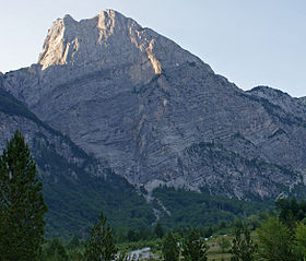
Massive south wall of Maja HarapitElevation 2,218 m (7,277 ft) Location Location Albania Range Prokletije Coordinates 42°26′30″N 19°48′45″E / 42.44167°N 19.8125°ECoordinates: 42°26′30″N 19°48′45″E / 42.44167°N 19.8125°E Geology Type Limestone Maja Harapit (Albanian: Maja e Harapit, or Maja e Arapit) is a mountain in the Prokletije range in the north of Albania. The mountain is 2,217 metres (7,274 ft) high, with its impressive 800 metres (2,600 ft) high south wall[1]' the northwestern edge of a large basin, where it dominates as a prominent rock formation, the conclusion of the Shala Valley and is one of the landmarks of Theth Valley. The mountain is on the edge of the National Parks Theth[2].
The mountain is located near the mountain pass of Qafa e Pejës (520 metres (1,710 ft)) north of Theth between the mountains of the Bjeshkët e Nemuna in the West - completed by the Maja Radohimës (2,570 metres (8,430 ft)) - and the Maja Jezercë massif in the east. While the steep south wall of the Shala Valley which is part of the mountain is actually based on a broad saddle between the two great massifs, the height of 2,000 metres (6,600 ft) steeply to a rocky point jutting which it juts from. The tip and the surrounding saddle is made of rugged rock, of sinkholes and caves penetrating karst formations [1][2].
Albania's longest horizontal cave is located beneath the south wall. Bulgarian researchers have explored its length at 2,585 metres (8,481 ft). The depth of the cave is 346 metres (1,135 ft). Within the cave 15 species have been discovered[3].
The south wall is considered the highest rock face of the Balkan peninsula and in the summer of 2010 was a tourist hotspot for the first time by a majority of tourists coming from Germany, especially big wall climbers throughout Europe.
The name Harapi from Albanian to English can be translated as, dark or Arabs.[2]
External links
References
- ^ a b Maja e Arapit, Geoquest Kletterführer. In: Geoquest Verlag. 2010-08-00. Retrieved on 2010-09-03.
- ^ a b c Christian Zindel, Barbara Hausamann: Wanderführer Nordalbanien – Thethi und Kelmend. Huber Verlag, München 25 October 2011, ISBN 978-3-940686-19-0.
- ^ International Caving Expedition Maja Arapit 2009. 2010-08-00. Retrieved on 2010-09-04. (Englisch)
Categories:- Mountains of Albania
- Prokletije Mountains
- Shkodër County geography stubs
Wikimedia Foundation. 2010.
