- Maine State Route 115
-
State Route 115
Route information Maintained by MaineDOT Length: 18.04 mi[1] (29.03 km) Major junctions West end:  /
/ U.S. Route 302/State Route 35 in North Windham
 US 202 / SR 4 at Windham/Gray town line[2]
 I-495 in Gray[2]

 US 202 / SR 4 / SR 26 / SR 100 in Gray[2]
 SR 231 in North Yarmouth[2]
 SR 9 in North Yarmouth[2]
East end:  State Route 88 in Yarmouth
Location Counties: Cumberland Highway system ←  SR 114
SR 116  →
→State Route 115 is a state highway in southern Maine, United States. It runs west to east for just over 18 miles (29 km) miles, from U.S. Route 302/State Route 35 in North Windham to State Route 88 in Yarmouth.
Route
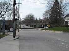 A Yarmouth section of Route 115 (Main Street), looking west toward the U.S. Route 1 overpass
Route 115 serves as the primary entrance to North Windham village from the east. Within North Windham, it crosses a bridge over Ditch Brook marking the location of a terminal moraine formerly containing Little Sebago Lake until destroyed by a flood on 4 June 1814.[3] Route 115 becomes concurrent with U.S. Route 202 at the Gray town line and parallels the west bank of the Pleasant River through West Gray until reaching Gray village after a bridge over the Maine Turnpike. Route 115 separates from Route 202 as the easterly road of the 5-way intersection at Gray village and proceeds southeasterly paralleling the west bank of the Royal River through Walnut Hill in North Yarmouth, where it is known as the Gray Road. Route 115 is known as West Main Street as enters the town of Yarmouth crossing the Maine Central Railroad Back Road and Lower Road a short distance northeast of their separation at Royal Junction.[2]
References
- ^ Floodgap Roadgap's RoadsAroundME: Maine State Route 115
- ^ a b c d e f DeLorme Mapping Copmpany ''The Maine Atlas and Gazetteer 13th Edition (1988) ISBN 0-89933-035-5 map 5
- ^ Varney, George J. A Gazetteer of the State of Maine (1886) B.B.Russell, Boston
Categories:- State highways in Maine
- Transportation in Cumberland County, Maine
- Northeastern United States road stubs


Wikimedia Foundation. 2010.