Gorges du Tarn

Gorges du Tarn
The Gorges du Tarn.

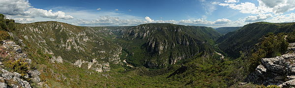
The Gorges du Tarn is a canyon formed by the Tarn River between the Causse Méjean and the Causse de Sauveterre, in southern France. The canyon, mainly located in the Lozère département, and partially in the Aveyron département, is about 53 kilometres (33 mi)-long (from the village of Quézac to Le Rozier, from 44°22′30″N 3°31′15″E / 44.375°N 3.52083°E / 44.375; 3.52083 to 44°11′36″N 3°12′20″E / 44.19333°N 3.20556°E / 44.19333; 3.20556Coordinates: 44°11′36″N 3°12′20″E / 44.19333°N 3.20556°E / 44.19333; 3.20556) and 400m to 600m deep.

Contents

Geography

The architecture of the gorges is relatively simple, with mesozoic limestone plateaux downstream presenting sub-vertical cliffs, though faults like the Hauterive Fault upstream explain the important water sources in the region of Saint-Enimie (the Burle source and the Coussac source, the latter joining the Tarn in an impressive waterfall), and the more complex geology.

In the quaternary, the gorges were also affected by a volcanic activity whose traces can be found in the Sauveterre Causse, in the form of a double volcanic dip, and in the basaltic rocks next to Eglanzines.

The climate is mediterranean, with relatively mild winters and very warm summers.

Activities

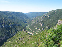
Tarn gorge, seen from the point sublime

Tourism is a main factor of development in the region, with activities that include :

  • Hiking
  • Kayaking
  • Speleology in the Causses
  • Visiting typical villages : Cirque de Saint-Chély-du-Tarn, ...
  • Rock climbing
  • Outdoor sports and leisures...

Architecture

Many castles have been built along the Gorges, most of them dating back to the Middle-Age, such as those of Castelbouc, La Caze, Hauterives, La Malène or Saint-Rome-de-Dolan…

See also

External links


Wikimedia Foundation. 2010.

Игры ⚽ Нужно решить контрольную?

Look at other dictionaries:

  • Gorges Du Tarn — Les gorges du Tarn, aux alentours de Saint Chély du Tarn …   Wikipédia en Français

  • Gorges du tarn — Les gorges du Tarn, aux alentours de Saint Chély du Tarn …   Wikipédia en Français

  • Gorges du Tarn — 44° 19′ 43″ N 3° 21′ 50″ E / 44.3287, 3.3640 …   Wikipédia en Français

  • Gorges du Tarn — Als Gorges du Tarn wird die große Schlucht im ersten Drittel des Flusses Tarn zwischen den Orten Le Rozier und Sainte Enimie genannt. Der Cirque de Pougnadoire mit dem Dorf Saint Chély du Tarn Inhaltsverzeichnis …   Deutsch Wikipedia

  • Gorges du tarn —    Les gorges du tarn sont un canyon creusé par le tarn entre le causse méjean et le causse de sauveterre …   L'Abécédaire du Vin

  • Les gorges du Tarn — Gorges du Tarn Les gorges du Tarn, aux alentours de Saint Chély du Tarn …   Wikipédia en Français

  • Communaute de communes des Gorges du Tarn et des Grands Causses — Communauté de communes des Gorges du Tarn et des Grands Causses Communauté de communes des Gorges du Tarn et des Grands Causses Ajouter une image Administration Pays France Région Languedoc Roussillon Département Lozère Date de création …   Wikipédia en Français

  • Communauté De Communes Des Gorges Du Tarn Et Des Grands Causses — Ajouter une image Administration Pays France Région Languedoc Roussillon Département Lozère Date de création …   Wikipédia en Français

  • Communauté de communes des gorges du tarn et des grands causses — Ajouter une image Administration Pays France Région Languedoc Roussillon Département Lozère Date de création …   Wikipédia en Français

  • Communauté de communes des Gorges du Tarn et des Grands Causses — Ajouter une image Administration Pays France Région Languedoc Roussillon Département Lozère Date de création 30 juillet  …   Wikipédia en Français

Share the article and excerpts

Direct link
Do a right-click on the link above
and select “Copy Link”