River Dulnain

River Dulnain
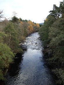
River Dulnain shortly before it joins the Spey, taken from the bridge in Dulnain Bridge

The River Dulnain (Gaelic: Abhainn Tuilnean) is a major left bank tributary of the River Spey in northeast Scotland. It rises in the eastern part of the Monadhliath Mountains (57°09′06″N 4°07′44″W / 57.1516°N 4.1288°W / 57.1516; -4.1288 (River Dulnain (source))) and flows in a generally northeastward direction through uninhabited country to Sluggan, where it is crossed by a high stone arch bridge constructed by General Wade to carry a military road. (The route now forms a part of Route 7 of the National Cycle Network.) Turning more easterly, the Dulnain passes beneath the modern A9 road which bypasses Carrbridge, the mainline railway and, In Carrbridge itself, the bridge carrying the B9153 road (former A9) which gives the village its name. The final section flowing eastnortheast to the village of Dulnain Bridge is accompanied by the A938 road. The river empties into the Spey (57°17′37″N 3°39′14″W / 57.2936°N 3.6538°W / 57.2936; -3.6538 (River Dulnain (mouth))) after passing beneath the A95 road and the disused bridge of the former Strathspey railway.[1]

Etymology

The name derives from the Scottish Gaelic tuil which means flood and ean which means stream and is perhaps descriptive of its reaction to rainfall.[2]

References

  1. ^ Ordnance Survey 1:50,000 scale Landranger map sheet 35 Kingussie & 36 Grantown and Aviemore
  2. ^ Ross, D. 2001 Scottish Place-names, Birlinn, Edinburgh

External links

Media related to River Dulnain at Wikimedia Commons

Coordinates: 57°14′31″N 3°56′24″W / 57.242°N 3.940°W / 57.242; -3.940


Wikimedia Foundation. 2010.

Игры ⚽ Нужен реферат?

Look at other dictionaries:

  • Dulnain Bridge — Coordinates: 57°18′16″N 3°39′54″W / 57.3045°N 3.6651°W / 57.3045; 3.6651 …   Wikipedia

  • Strathspey Railway (preserved) — The Strathspey Railway (SR) in Badenoch and Strathspey, Highland, Scotland, operates a 10 mile (16 km) preserved railway from Aviemore to Broomhill via Boat of Garten, part of the former Inverness and Perth Junction Railway (later part of… …   Wikipedia

  • Old military roads of Scotland — The remains of one of the military roads near the Corrieyairack Pass A network of military roads was constructed in the Scottish Highlands during the middle part of the 18th century as part of an attempt by the British Government to bring order… …   Wikipedia

  • Carrbridge — infobox UK place country = Scotland official name= Carrbridge gaelic name= Drochaid Charra scots name= population = 708 os grid reference= NH905225 map type=Scotland latitude=57.2833333 longitude= 3.8166667 unitary scotland= Highland lieutenancy… …   Wikipedia

  • Cairngorms — This article is about the Scottish mountain range. For other uses, see Cairngorm. The Cairngorms are a mountain range in the eastern Highlands of Scotland closely associated with the mountain of the same name Cairn Gorm. The Cairngorms from Càrn… …   Wikipedia

  • Scottish Highlands — The Scottish Highlands (Scottish Gaelic: A Ghàidhealtachd , Scots: Hielans ) include the rugged and mountainous regions of Scotland north and west of the Highland Boundary Fault, although the exact boundaries are not clearly defined, particularly …   Wikipedia

  • Cairngorms National Park — Infobox protected area | name = Cairngorms National Park iucn category = V caption = The Linn of Dee on the River Dee near Braemar. Linn is the Scots word for waterfall . locator x = locator y = location = Cairngorms, Scotland, Moray,… …   Wikipedia

  • List of community council areas in Scotland — This is a list of community council areas established in each of the council areas of Scotland.Aberdeen CityThere are 31 community council areas in the council area. Those marked with an asterisk have a community council. [… …   Wikipedia

Share the article and excerpts

Direct link
Do a right-click on the link above
and select “Copy Link”