Drumburgh Castle

Drumburgh Castle
Drumburgh Castle
Cumbria, England
Drumburgh Castle - geograph.org.uk - 912711.jpg
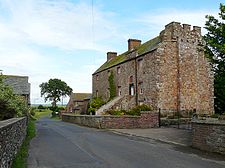
Drumburgh Castle today
Drumburgh Castle is located in Cumbria
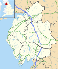
Shown within Cumbria
Type Pele tower
Coordinates grid reference NY265597
Construction
materials
Red sandstone

Drumburgh Castle is a medieval pele tower in the village of Drumburgh, in Cumbria, England.

Contents

History

A pele tower was originally built on this site, near the village of Burgh, by Robert le Brun in 1307, on the site of a former tower that had been part of Hadrian's Wall.[1] The construction used red sandstone masonry from the wall for its construction.[2] Thomas Dacre rebuilt the castle in 1518, producing what contemporaries described as "neither castle nor tower but a house of strength".[3] The house was altered again between 1678 to 1681 by John Alglionby, producing the current design.[4] The property today has a distinctive first floor doorway and staircase - a later addition to the castle - decorated with the Dacre coat of arms, and has parts of a Roman shrine incorporated into its stonework.[5]

See also

Biliography

References

  1. ^ Drumburgh Castle, The Gatehouse website, accessed 19 April 2011; Pettifer, p.40.
  2. ^ Pettifer, p.40.
  3. ^ Pettifer, p.40.
  4. ^ Drumburgh Castle, The Gatehouse website, accessed 19 April 2011.
  5. ^ Richards and Clegg, p.177.

Wikimedia Foundation. 2010.

Игры ⚽ Нужно решить контрольную?

Look at other dictionaries:

  • Drumburgh — Coordinates: 54°55′N 3°09′W / 54.92°N 3.15°W / 54.92; 03.15 …   Wikipedia

  • Coggabata — Coordinates: 54°55′37″N 3°08′53″W / 54.927°N 3.148°W / 54.927; 3.148 …   Wikipedia

  • List of Grade I listed buildings in Cumbria — There are over 6000 Grade I listed buildings in England. This page is a list of these buildings in the county of Cumbria, sub divided by district.Allerdale* Church of St Andrew, Aikton * Harby Brow Tower, farmhouse barn, Allhallows * Whitehall,… …   Wikipedia

  • Liste der Grade-I-Baudenkmäler in Cumbria — Die Liste der Grade I Baudenkmäler in Cumbria nennt diejenigen der mehr als 6000 als Grade I eingestuften Gebäude in England, die sich in der Grafschaft Cumbria befinden. Die Liste ist nach Bezirken unterteilt. Inhaltsverzeichnis 1 Allerdale 2… …   Deutsch Wikipedia

  • Hadrianswall — hf Hadrianswall Alternativname vallum aelium Limes Britannien Datierung (Belegung) 2. bis 5. Jahrhundert n. Chr. Typ Sperrwerk mit Zwischentürmen, Meilenkastellen und Grabensystem …   Deutsch Wikipedia

  • Hadrian's Wall — This article is about the fortification in Northern England. For the Broad Wall of Jerusalem, see Broad Wall (Jerusalem). Coordinates: 55°01′27″N 2°17′33″W / 55.02417°N 2 …   Wikipedia

  • List of places in Cumbria — This is a list of cities, towns and villages in the county of Cumbria, England. See the list of places in England for places in other counties.compactTOC NOTOC A*Abbey Town, Above Derwent, Ackenthwaite, Adgarley, Aglionby *Aiketgate, Aikhead,… …   Wikipedia

  • Hadrians Wall — Der Hadrianswall in der Nähe von Greenhead Überreste von Kastell 39 Der Hadrianswall (lat. Vallum Hadriani) war ein römisches …   Deutsch Wikipedia

  • Rudge Cup — The Rudge Cup is a small enamelled bronze cup found in 1725 at Rudge, in Wiltshire. The cup was found down a well on the site of a Roman villa. It is important in that it lists five of the forts on the western section of Hadrian s Wall, thus… …   Wikipedia

Share the article and excerpts

Direct link
Do a right-click on the link above
and select “Copy Link”