- Dospat Reservoir
-
Dospat Dam
Язовир Доспат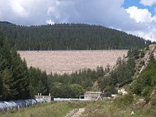
Dospat DamCountry Bulgaria Location Smolyan Province, Pazardzhik Province Coordinates 41°41′54″N 24°05′10″E / 41.69833°N 24.08611°ECoordinates: 41°41′54″N 24°05′10″E / 41.69833°N 24.08611°E Status Active Opening date 1969 Owner(s) NEK EAD Dam and spillways Type of dam Rock-fill with clay core Height 60.5 m (198 ft) Length 230 m (750 ft) Impounds Dospat River Spillways 1 Type of spillway trench type Spillway capacity 267 m3/s (349 cu yd/s) Reservoir Capacity 449,220,000 m3 (587,560,000 cu yd) Catchment area 432.3 km2 (166.9 sq mi) Surface area 22 km2 (8.5 sq mi) Max. water depth 57.75 m (189.5 ft) 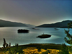 Dospat Dam as seen from the outskirts of Dospat.
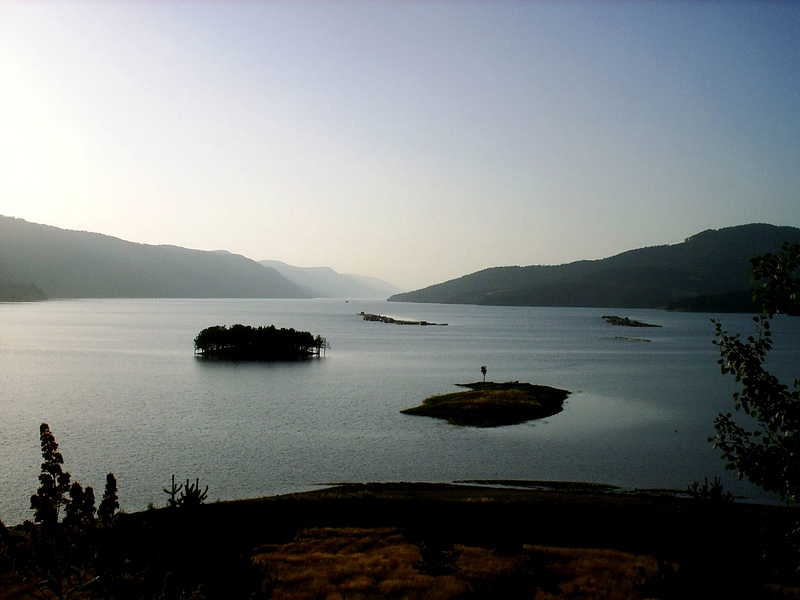
Dospat Reservoir (Bulgarian: язовир Доспат) is situated in the western part of the Rhodope Mountains, Bulgaria. The reservoir (formed by a dam in the town of Dospat, 82 km (51 mi) west of Smolyan) stretches nearly 19 km (12 mi) northwest to the city of Sarnitsa. At 1,200 m (3,900 ft) above the sea level, it is one of the highest dams in Bulgaria in terms of altitude, and, with its 22 km2 (8.5 sq mi) of water area, the second largest in capacity. It is fed by the Dospat River.
The dam, which creates the lake, is built for hydroelectricity generation. There is no HPP (hydroelectric power plant) installed at the dam but rather the water is taken to the Teshel HPP and then further down the Devin HPP and the Vacha River with its HPPs, dams and reservoirs (Tsankov Kamak HPP, Vacha Reservoir, Krichim Reservoir, Vacha II HPP, Krichim HPP and Vacha I HPP). Besides that, a minimum of 0.15 m3/s (0.20 cu yd/s) is constantly released for sanitation of the Dospat River riverbed where the average input to the reservoir is 7.9 m3/s (10.3 cu yd/s).
The flora and fauna around the reservoir are diverse and the geography offers breathtaking sights. Old coniferous forests surround the lake. On the northern bank where the town of Sarnitsa and Krushata neighborhood are located. The terrain is hilly, with meadows and arable land available, used for grazing, potato growing and other agricultural activities. Parallel to the south bank are steep slopes covered in spruce and this bank is where most holiday cabins and hotels are located.
The reservoir is rich in fish. It is stocked with perch, trout (rainbow, brown, brook), carp, European chub, common rudd, common roach, pumpkinseed, wels catfish, Danube Bleak and various members of Carassius. Trout are reared in cages within the reservoir. Most types of fishing are practiced: spinning with lures, fly fishing, and others.
In the surrounding areas there are a number of other large dams, including Vacha, Golyam Beglik, Batak and Shiroka Polyana. The area offers great opportunities for recreation and tourism.
Accessibility is, however, rather poor. Four main mountain roads link the reservoir to the rest of the world. One from Batak, a second from Velingrad to Sarnitsa, a third from Devin and a fourth from Gotse Delchev to the town of Dospat. The one from Batak allows accessibility to some of the other Rhodope dams along its length. It forks into two roads; one leading to the town of Dospat and the other to Sarnitsa. This road to Sarnitsa is in places very rutted and may prove a challenge to navigate. Along the south bank there runs a rough dirt track from Sarnitsa to Dospat but this is only used to access the holiday spots.
See also
- Reservoirs and dams in Bulgaria
External links
Categories:- Reservoirs and dams in Bulgaria
- Smolyan Province
- Pazardzhik Province
- Rhodopes
- Chech

Wikimedia Foundation. 2010.