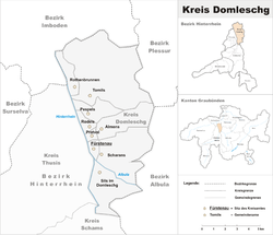
- Domleschg (Kreis)
-
Kreis Domleschg
Kreis Domleschg— Sub-district — Country  Switzerland
Canton  Graubünden
Capital Fürstenau Area – Total 73.94 km2 (28.5 sq mi) Population (2009) – Total 4,278 – Density 57.9/km2 (149.9/sq mi) Time zone CET (UTC+1) – Summer (DST) CEST (UTC+2) Municipalities 8 The Kreis Domleschg forms, together with the sub-districts of Avers, Rheinwald, Schams and Thusis, the Bezirk ("district") Hinterrhein of the Canton Graubünden in Switzerland. The district office is located in Fürstenau.
Geography
Georgraphically, the Kreis is located in the lower part of the Hinterrhein, below the Viamala gorge, on the left bank of the river. This part of the valley is known as the Domleschg/Heinzenberg valley. The right bank forms the Kreis Thusis.
Municipalities
Coat of arms Name Residents
(Dec. 2009)Area
in sq kmBFS No. 
Almens 223 8.34 3631 
Fürstenau 353 1.32 3633 
Paspels 475 4.59 3634 
Pratval 231 0.77 3635 
Rodels 266 1.68 3636 
Rothenbrunnen 307 3.11 3637 
Scharans 837 14.29 3638 
Sils im Domleschg 863 9.28 3640 
Tomils 723 30.56 3671 External links
- Domleschg in German, French and Italian in the online Historical Dictionary of Switzerland.
- This article incorporates information from the equivalent article on the German Wikipedia.
Categories:- Graubünden geography stubs
- Districts of the canton of Graubünden
Wikimedia Foundation. 2010.

