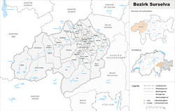
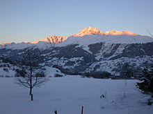
- Surselva District
-
Surselva District
District Surselva
Bezirk Surselva— District — Country  Switzerland
Canton  Graubünden
Capital Ilanz Area – Total 1,373.54 km2 (530.3 sq mi) Population (2009) – Total 21,915 – Density 16/km2 (41.3/sq mi) Time zone CET (UTC+1) – Summer (DST) CEST (UTC+2) Municipalities 42 Surselva District is an administrative district in the canton of Graubünden, Switzerland. It has an area of 1,373.39 km2 (530.27 sq mi) and has a population of 21,915 (as of 31 December 2009).[1]
The Surselva encompasses the valley of the Vorderrhein and all its side valleys, from the source near the Oberalppass all the way down towards Reichenau (where the Vorderrhein joins the Hinterrhein to form the then only Rhine called river). The district ends before that confluence at the huge forest on the giant debris of Flims Rockslide that is responsible for the name of the region: The debris area lack of water and soil and were ever left as a big forest as it was useless for farming. This forest (romonsch: selva) is the border for "Sur-selva" (meaning "above the forest"). The Surselva is one of the few areas in Switzerland that is mainly Romansh-speaking (another notable valley being the Engadin, the valley of the Inn). There are a few German-speaking communities in the Surselva, two notable ones being Obersaxen and Vals, which were founded in the thirteenth century by the Walser.
Sub division: Kreis
It consists of five Kreise (sub-districts) and forty-three municipalities:
Disentis sub-district Municipality Population
(31 December 2009)[1]Area (km²) Breil/Brigels 1,277 50.84 Disentis/Mustér 2,121 91.08 Medel (Lucmagn) 451 136.20 Schlans 88 8.83 Sumvitg 1,310 101.83 Trun 1,173 43.03 Tujetsch 1,791 133.92 Ilanz sub-district Municipality Population
(31 December 2009)[1]Area (km²) Castrisch 409 7.18 Falera 577 22.35 Ilanz 2,338 4.50 Laax 1,336 31.68 Ladir 109 7.21 Luven 205 6.83 Mundaun 311 8.59 Pitasch 107 10.81 Riein 66 15.82 Ruschein 360 12.54 Sagogn 661 6.95 Schluein 486 4.81 Schnaus 132 2.99 Sevgein 211 4.60 Valendas 292 22.79 Versam 242 16.77 Lumnezia/Lugnez sub-district Municipality Population
(31 December 2009)[1]Area (km²) Cumbel 249 4.45 Degen 249 6.74 Duvin 88 17.91 Lumbrein 380 37.83 Morissen 242 5.69 St. Martin 36 22.93 Suraua 252 24.20 Vals 1,047 152.58 Vella 434 7.91 Vignogn 178 7.38 Vrin 246 71.23 Ruis sub-district Municipality Population
(31 December 2009)[1]Area (km²) Andiast 228 13.63 Obersaxen 812 61.54 Pigniu 31 17.98 Rueun 416 11.58 Siat 181 13.48 Waltensburg/Vuorz 374 32.32 Safien sub-district (Safien valley) Municipality Population
(31 December 2009)[1]Area (km²) Safien 314 100.58 Tenna 105 11.28 Languages
Romansh is the predominant language in the district, most of which speak the Sursilvan dialect. There is a large German-speaking minority in Surselva, notably the Walser settlements of Obersaxen and Vals. However, the percentage of Romansh-speakers is on the decline. Traditional Romansh-speaking cities such as Ilanz are losing ground to German.
Languages of Surselva District, GR Languages Census 2000 Number Percent German 7,335 34.5 % Romansh 12,606 59.4 % Italian 289 1.4 % TOTAL 21,231 100 % A long distance hike is signposted to follow the main Vorderrhein River through the whole of the district[2]
References
- ^ a b c d e f Swiss Federal Statistical Office, MS Excel document – Bilanz der ständigen Wohnbevölkerung nach Kantonen, Bezirken und Gemeinden (German) accessed 25 August 2010
- ^ Hiking Surselva, Switzerland on official tourism board
Categories:- Districts of the canton of Graubünden
- Alpine Rhine basin
- Graubünden geography stubs
Wikimedia Foundation. 2010.


