- Dokhu
-
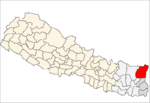
Dokhu — Village development committee — Location in Nepal
 Dokhu
DokhuCoordinates: 27°20′N 87°41′E / 27.34°N 87.68°ECoordinates: 27°20′N 87°41′E / 27.34°N 87.68°E Country  Nepal
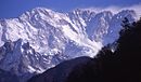
NepalZone Mechi Zone District Taplejung District Population (1991) – Total 3,142 Time zone Nepal Time (UTC+5:45) Dokhu is a village development committee in the Himalayas of Taplejung District in the Mechi Zone of north-eastern Nepal. At the time of the 1991 Nepal census it had a population of 3142 people living in 581 individual households.[1]
Dokgu village development committee in the taplejung district is place of corn house of taplejung. pepplesof different ethnic groups live happily here. vegetable and fruits farming is main occupation of here.
References
- ^ "Nepal Census 2001". Nepal's Village Development Committees. Digital Himalaya. http://www.digitalhimalaya.com/collections/nepalcensus/form.php?selection=1. Retrieved 19 November 2008.
External links
Ambegudin · Ankhop · Chaksibote · Change · Dhungesaghu · Dokhu · Dummrise · Ekhabu · Hangdeva · Hangpang · Kalikhola · Khamlung · Khejenim · Khewang · Khokling · Lelep · Limbudin · Lingtep · Linkhim · Liwang · Mamangkhe · Nalbu · Nankholyang · Nidhuradin · Olangchung Gola · Paidang · Papung · Pedang · Phakumba · Phawakhola · Phulbari · Phungling · Phurumbu · Sadewa · Sangu · Santhakra · Sawa · Sawadin · Sawalakhu · Sikaicha · Sinam · Surumakhim · Tapethok · Tellok · Thechambu · Thinglabu · Thukima · Thumbedin · Tiringe · Yamfudin
 Categories:
- Populated places in Taplejung District
- Mechi Zone geography stubs


Wikimedia Foundation. 2010.