- Dode, Kent
-
This article is about the village and church in Kent. For other uses, see Dode.
Coordinates: 51°20′53″N 0°23′42″E / 51.34817°N 0.39491°E
Dode 
 Dode
Dode
Dode shown within KentOS grid reference TQ6663 District Gravesham Shire county Kent Region South East Country England Sovereign state United Kingdom Post town GRAVESEND Postcode district DA12 EU Parliament South East England UK Parliament Gravesham Website http://www.dodevillage.com/ List of places: UK • England • Kent Dode (in Old English, Dowde) was a village in England that was wiped out by the Black Death in 1349. All that remains is the deconsecrated church, which was rebuilt in the 1990s.
Contents
History and location
Archaeological evidence shows habitation in the Dode area during the time of the Roman Empire.[1]
The church at Dode was built during the reign of William II of England at some point between 1087 and 1100.[2] It was built on a man-made mound. The nearby hill is known as "Holly Hill" which is a corruption of "Holy Hill", and the lane which leads to the village is "Wrangling Lane", showing that the mound could be the site of a meeting place.[3] The church stands at the end of a 10-mile long easterly running ley line connecting three pre-reformation churches, two Roman sites, a Bronze Age burial ground, and two of the Medway megaliths - the Coffin Stone and Kit's Coty House.[2]
The village of Dode was virtually wiped out by the Black Death during the 14th century, and its church last used as a place of worship in 1367, then deconsecrated[3] on the orders of Thomas Trilleck, the Bishop of Rochester.[1][4] It was originally twinned with another Early Norman church in Paddlesworth (now in Snodland).[5]
Stones from the church were used to build a Medieval church nearby.[1]
Folklore
According to local legend, the last survivor of the Black Death at Dode was a seven-year-old girl known as the Dodechild. It is said she took refuge in the church after all the other villagers were dead, and died within its walls. The Dodechild is supposed to haunt the churchyard, having first appeared on a Sunday morning each month for several years, and then every seven years.[3]
Rebuilding of the church
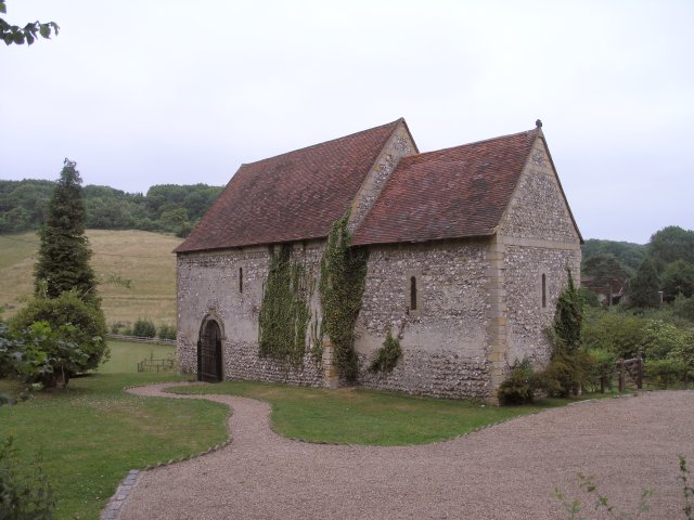
 The rebuilt Church at Dode.
Following the Black Death, the village was abandoned, and the church stood empty for centuries. In 1901 it was purchased by an antiquarian, George M Arnold, Mayor of Gravesend.[6] He restored the walls and roof of the church and in 1954 the Arnold family returned the building to the Catholic Church.[7] It was rededicated as the Church of Our Lady of the Meadows and mass was celebrated there at least once a year.[7]
Eventually the building deteriorated again and was vandalised.[8] In 1990 Doug Chapman, a chartered surveyor who had worked at Canterbury Cathedral, purchased the church and began restoring the building,[8] originally with the intention of turning it into a weekend home.[1] Since 1999 it has been licensed as a civil wedding venue.[2]
The wedding venue hit the British press in December 2009 because of the snowfall which occurred across the country. A bride-to-be called BBC Radio Kent for assistance when she realised that the transport arranged for her wedding would not be able to travel down the narrow lane to Dode. A number of volunteers stepped forward, providing enough four-wheel drive cars to transport the wedding party and their guests both to the venue at Dode, and then afterwards to the Leather Bottle pub in Cobham.[9]
See also
References
- ^ a b c d Glancey, Jonathan (1996-04-16). "One man's revival of ancient English rites". Independent.co.uk. http://www.independent.co.uk/arts-entertainment/art/news/one-mans-revival-of-ancient-english-rites-1305140.html. Retrieved 2009-12-19.
- ^ a b c Chapman, Doug. "A Brief History of Dode". Dodevillage.com. http://www.dodevillage.com/History.htm. Retrieved 2009-12-19.
- ^ a b c "The Lost Village of Dowde". Haunted Kent. http://www.hauntedkent.com/x0001a.aspx. Retrieved 2009-12-18.[dead link]
- ^ "A brief explanatory note on the churches and parishes of Paddlesworth and Dode". Medway.gov.uk. http://cityark.medway.gov.uk/query/results/?Mode=Search&PathList=%2FEcclesiastical_Non_Parochial_or_Out_Area%2F%0A&SearchWords=Dode+Church&DateList=&Boolean=AND&Results=50&Exact=yes. Retrieved 2009-12-19.
- ^ "TQ6663: Dowde (or Dode) Church". Geograph.co.uk. 2006-06-26. http://www.geograph.org.uk/photo/21542. Retrieved 2009-12-18.
- ^ "George Matthews Arnold". Discover Gravesham. Gravesham Borough Council. http://www.discovergravesham.co.uk/famous-people/george-matthews-arnold.html. Retrieved 2010-01-14.
- ^ a b "A History of English Martyrs Strood". Church Handbook 1975–6. English Martyrs Roman Catholic Church. 1975. http://www.rc.net/southwark/englishmartyrs/history.htm. Retrieved 2010-01-14.
- ^ a b Pattison, Jo (2009-12-14). "Discover the lost village of Dode". BBC News. http://news.bbc.co.uk/local/kent/hi/people_and_places/history/newsid_8405000/8405634.stm. Retrieved 2009-12-18.
- ^ "Snow almost stops bride getting to the church on time... until some kindly villagers step in". Daily Mail. 2009-12-18. http://www.dailymail.co.uk/news/article-1236945/Snow-stops-bride-getting-church-time--helpful-villagers-step-in.html. Retrieved 2009-12-19.
External links
Towns and villages in the Borough of Gravesham  Chalk · Cobham · Culverstone Green · Dode · Harvel · Higham · Istead Rise · Luddesdown · Meopham · Meopham Green · Northfleet · Painters Ash · Singlewell or Ifield · Shorne · Sole Street · Springhead · Thong · Vigo
List of places in Kent Categories:- Gravesham
- Villages in Kent
- Lost villages
- Norman architecture


Wikimedia Foundation. 2010.