Derwent Ings

Derwent Ings
Derwent Ings
Site of Special Scientific Interest
Cygnus bewickii 01.jpg
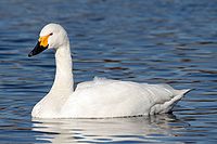
Adult Bewick's Swan, Cygnus columbianus bewickii'
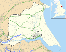
Derwent Ings is located in East Riding of Yorkshire
{{{alt}}}
Shown within East Riding of Yorkshire
Area of Search Humberside
Grid reference SE 703347
Coordinates 53°54′40″N 0°55′50″W / 53.911236°N 0.930547°W / 53.911236; -0.930547Coordinates: 53°54′40″N 0°55′50″W / 53.911236°N 0.930547°W / 53.911236; -0.930547
Interest Biological
Area 1,636.91 acres (6.6243 km2; 2.55767 sq mi)
Notification 1975 (1975)
Natural England website

Derwent Ings is a Site of Special Scientific Interest (SSSI) in the East Riding of Yorkshire, England. [1] Derwent Ings is of international significance and has been designated a Wetland of International Importance under the Ramsar Convention[2] and as a Special Protection Area under the terms of the European Community Directive. Part of the site is owned by the Yorkshire Wildlife Trust[3] and is managed in conjunction with English Nature. It lies adjacent to the River Derwent between Sutton upon Derwent and Menthorpe. The site, which was designated a SSSI in 1975, consists of a series of neutral alluvial flood meadows, fen and swamp communities and freshwater habitats. It is one of the most important examples of agriculturally unimproved species-rich alluvial flood meadow habitat remaining in the UK.

In winter the Ings support internationally important concentrations of waterfowl, in excess of 20,000 individuals, together with nationally important numbers of Bewick's swan, teal, wigeon, mallard, pochard, golden plover and ruff.

References

  1. ^ "Derwent Ings" (PDF). Natural England. 1988. http://www.sssi.naturalengland.org.uk/citation/citation_photo/1002114.pdf. Retrieved 2009-07-21. 
  2. ^ Ramsar sites database, retrieved 2009-12-01
  3. ^ "Nature Reserves :Wheldrake Ings". Yorkshire Wildlife Trust. http://www.ywt.org.uk/nature_reserves.php?id=60. Retrieved 2009-07-21. 

Wikimedia Foundation. 2010.

Игры ⚽ Поможем написать курсовую

Look at other dictionaries:

  • Derwent (Yorkshire) — Derwent Flutschutzwehr an der Flussmündung in die OuseVorlage:Infobox Fluss/KARTE fehlt Daten …   Deutsch Wikipedia

  • River Derwent, Yorkshire — Geobox River name = Derwent native name = other name = Darwent archaically other name1 = map size = map caption = Map of the Catchment Area of the River Derwent country = England country1 = region = Yorkshire region1 = city = city1 = length = 115 …   Wikipedia

  • List of Sites of Special Scientific Interest in North Yorkshire — This is a list of the Sites of Special Scientific Interest (SSSIs) in North Yorkshire. Note that Natural England, the designating body for SSSIs in England, uses the 1974–1996 county system, and this list follows the same approach, rather than,… …   Wikipedia

  • List of Sites of Special Scientific Interest in Humberside — This is a list of the Sites of Special Scientific Interest (SSSIs) in Humberside. Note that English Nature, the designating body for SSSIs in England, uses the 1974 1996 county system, and the same approach is followed here, rather than, for… …   Wikipedia

  • List of Nature Conservation Review sites — The following is a list of sites listed in Derek Ratcliffe s 1979 book A Nature Conservation Review . The headings, subheadings, site codes and site names are the same as those used in the original work.Coastlandsoutheast Englandouth west… …   Wikipedia

  • Wheldrake — infobox UK place country = England latitude= 53.8960 longitude= 0.9612 official name= Wheldrake population= 1,909 unitary england= York lieutenancy england=North Yorkshire region= Yorkshire and the Humber post town= YORK postcode district = YO19… …   Wikipedia

  • Redcar — Coordinates: 54°37′07″N 1°04′07″W / 54.61856°N 1.06856°W / 54.61856; 1.06856 …   Wikipedia

  • Yorkshire — Geografie Status: Traditionelle Grafschaft Region: Yorkshire and the …   Deutsch Wikipedia

  • Vale of Pickering — The Vale of Pickering is a low lying flat area of land in North Yorkshire, England. It is drained by the River Derwent. The landscape is rural with scattered villages and small market towns. It has been inhabited continuously from the Mesolithic… …   Wikipedia

  • Civil parishes in Cumbria — A map of Cumbria, showing the districts: (1) Barrow in Furness; (2) South Lakeland; (3) Copeland; (4) Allerdale; (5) Eden; and (6) Carlisle. A civil parish is a subnational entity, forming the lowest unit of local government in England. There are …   Wikipedia

Share the article and excerpts

Direct link
Do a right-click on the link above
and select “Copy Link”