- Portsmouth International Airport at Pease
Infobox Airport
name = Portsmouth International Airport at Pease
nativename = Pease Air National Guard Base
IATA = PSM
ICAO = KPSM
FAA = PSM
type = Public / Military
owner = Pease Development Authority
operator =
city-served =Portsmouth, New Hampshire
location =
elevation-f = 100
elevation-m = 30
coordinates = coord|43|04|41|N|070|49|24|W|region:US_type:airport_scale:40000
website =
r1-number = 16/34
r1-length-f = 11,321
r1-length-m = 3,451
r1-surface = Asphalt/Concrete
stat-year = 2007
stat1-header = Aircraft operations
stat1-data = 51,673
stat2-header = Based aircraft
stat2-data = 107
footnotes = Sources: airport website [http://www.peasedev.org/web/aviation/aviation.htm Portsmouth International Airport at Pease] , official site] and FAAFAA-airport|ID=PSM|use=PU|own=PU|site=13386.*A, effective 2008-06-05]Portsmouth International Airport at Pease airport codes|PSM|KPSM|PSM is a public-use
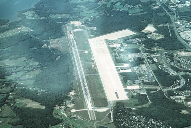
airport located onenautical mile (2 km) west of thecentral business district of Portsmouth, a city in Rockingham County,New Hampshire ,United States . It is owned by the Pease Development Authority.The airport is located within the Pease International Tradeport [ [http://www.peasedev.org/pease/tradeport.asp Pease International Tradeport] , official site] , a result of the ongoing redevelopment of the former
Pease Air Force Base which was closed underBase Realignment and Closure (BRAC) Commission action in the late 1980s and early 1990s.It shares the runway with the Pease Air National Guard Base, which is actively utilized by the
157th Air Refueling Wing (157 ARW) of the New HampshireAir National Guard , operating theKC-135R Stratotanker aircraft. [ [http://www.nhpeas.ang.af.mil/ 157th Air Refueling Wing at Pease Air National Guard Base] , official site]Pease is one of 7 Launch Abort Sites and one of 18 Emergency Landing Sites for
NASA space shuttle orbiters. [ [http://www.northcom.mil/News/2007/060507.html DOD Support to manned space operations for STS-117] ]The airport does not currently offer scheduled commercial airline service. It served as a hub for Pan Am from 1998 until 2005, when all mainline Pan Am flights at the airport were suspended. It was also one of a handful of airports serviced by the short-lived
Skybus Airlines which ceased operation in the Spring of 2008.Facilities and aircraft
Portsmouth International Airport at Pease covers an area of 3,000
acre s (1,214 ha) at anelevation of 100 feet (30 m) abovemean sea level . It has oneconcrete andasphalt pavedrunway designated 16/34 which measures 11,321 by 150 feet (3,451 x 46 m).For the 12-month period ending October 1, 2007, the airport had 51,673 aircraft operations, an average of 141 per day: 68%
general aviation , 22% military, 7%air taxi and 3% scheduled commercial. At that time there were 107 aircraft based at this airport: 52% single-engine, 19% multi-engine, 12% jet, 2%helicopter and 15% military.References
External links
*
*
*
Wikimedia Foundation. 2010.