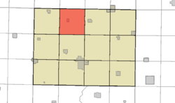
- Delana Township, Humboldt County, Iowa
-
Delana Township — Township — Location in Humboldt County Coordinates: 42°51′50″N 94°16′17″W / 42.86389°N 94.27139°WCoordinates: 42°51′50″N 94°16′17″W / 42.86389°N 94.27139°W Country  United States
State  Iowa
IowaCounty Humboldt Established 1870 Area - Total 36.3 sq mi (94 km2) - Land 36.3 sq mi (94 km2) - Water 0.0 sq mi (0 km2) Elevation 1,135 ft (346 m) Population (2000) - Total 532 - Density 15/sq mi (5.8/km2) Time zone CST (UTC-6) - Summer (DST) CDT (UTC-5) ZIP codes 50519 (Bode) GNIS feature ID 0467697 Delana Township is one of twelve townships in Humboldt County, Iowa, USA.[1] As of the 2000 census, its population was 532.
Contents
Geography
According to the United States Census Bureau, Delana Township covers an area of 36.3 square miles (94 km2), all of this is land.
Cities, towns, villages
Adjacent townships
- Riverdale Township, Kossuth County (north)
- Sherman Township, Kossuth County (northeast)
- Humboldt Township (east)
- Grove Township (southeast)
- Rutland Township (south)
- Avery Township (southwest)
- Wacousta Township (west)
- Garfield Township, Kossuth County (northwest)
Cemeteries
The township contains St. Olaf Cemetery, and Union Cemetery, also Bode Memorial Park.[1]
Political districts
- Iowa's 4th congressional district
- State House District 4
References
- United States Census Bureau 2008 TIGER/Line Shapefiles
- United States Board on Geographic Names (GNIS)
- United States National Atlas
- ^ a b c "Delana township, Humboldt County, Iowa (IA)." U.S. Census Bureau. Breakdown. Retrieved January 17, 2010.
External links
Municipalities and communities of Humboldt County, Iowa County seat: Dakota City Cities Townships Ghost town Arnold | Jones Siding | Unique
Footnotes ‡This populated place also has portions in an adjacent county or counties
Categories:- Townships in Humboldt County, Iowa
Wikimedia Foundation. 2010.


