- Dargobądz
-
Dargobądz — Village — Church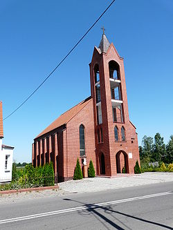

 Dargobądz
Coordinates: 53°52′21″N 14°32′4″E / 53.8725°N 14.53444°E Country  Poland
Voivodeship West Pomeranian County Kamień Gmina Wolin Population 380 Website http://dargobadz.tnb.pl/news.php Dargobądz [darˈɡɔbɔnt͡s] (formerly German Dargebanz) is a village in the administrative district of Gmina Wolin, within Kamień County, West Pomeranian Voivodeship, in north-western Poland.[1] It lies approximately 7 kilometres (4 mi) north-west of Wolin, 20 km (12 mi) south-west of Kamień Pomorski, and 51 km (32 mi) north of the regional capital Szczecin.
Before 1945 the area was part of Germany. For the history of the region, see History of Pomerania.
The village has a population of 380.
References
Town and seat 
Villages Chynowo · Dargobądz · Darzowice · Dobropole · Domysłów · Dramino · Gogolice · Jagienki · Jagniątkowo · Jarzębowo · Karnocice · Kodrąb · Kodrąbek · Kołczewo · Koniewo · Korzęcin · Ładzin · Laska · Łojszyno · Łuskowo · Mierzęcin · Mokrzyca Mała · Mokrzyca Wielka · Ostromice · Parłowo · Piaski Wielkie · Płocin · Rabiąż · Recław · Rekowo · Rzeczyn · Sierosław · Siniechowo · Skoszewo · Strzegowo · Sułomino · Świętouść · Troszyn · Troszynek · Unin · Warnowo · Wartowo · Wiejkówko · Wiejkowo · Wisełka · Zagórze · Zastań · Żółwino
Categories:- Villages in Kamień County
- Kamień County geography stubs


Wikimedia Foundation. 2010.