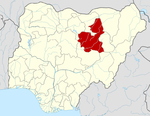
Damban

Damban
Damban
—  LGA and town  —
Country  Nigeria
State Bauchi State
Time zone WAT (UTC+1)

Damban is a Local Government Area of Bauchi State, Nigeria. Its headquarters are in the town of Damban.

It has an area of 1,077 km² and a population of 150,922 at the 2006 census.

The postal code of the area is 751.[1]

References


Wikimedia Foundation. 2010.

Игры ⚽ Поможем написать курсовую

Look at other dictionaries:

  • Khmer Rouge period (1975–1979) — The Khmer Rouge from 1975 until 1979 when Cambodia was ruled by the government of Pol Pot and his Khmer Rouge party the official name of the country was Democratic Kampuchea ( km. កម្ពុជាប្រជាធិបតេយ្យ, French: Kampuchea démocratique , Vietnamese …   Wikipedia

  • Khmer Rouge rule of Cambodia — History of Cambodia This article is part of a series Early history …   Wikipedia

  • Bauchi State —   State   Nickname(s): Pearl of Tourism …   Wikipedia

  • Muntii Trascaului — 46.33333333333323.51369Koordinaten: 46° 20′ N, 23° 30′ O …   Deutsch Wikipedia

  • Muntii trascaului — 46.33333333333323.51369Koordinaten: 46° 20′ N, 23° 30′ O …   Deutsch Wikipedia

  • Munţii Trascăului — 46.33333333333323.51369Koordinaten: 46° 20′ N, 23° 30′ O …   Deutsch Wikipedia

  • Trascau — 46.33333333333323.51369Koordinaten: 46° 20′ N, 23° 30′ O …   Deutsch Wikipedia

  • Trascău — 46.33333333333323.51369Koordinaten: 46° 20′ N, 23° 30′ O …   Deutsch Wikipedia

  • Trascău-Gebirge — 46.33333333333323.51369 Koordinaten: 46° 20′ N, 23° 30′ O …   Deutsch Wikipedia

  • Ningi, Nigeria — Ningi, Nigeria …   Wikipedia

Share the article and excerpts

Direct link
Do a right-click on the link above
and select “Copy Link”