- D58 road (Croatia)
-
D58 state road
Route information Length: 43.0 km (26.7 mi) Major junctions From: Šibenik (port)  D8 near Šibenik
 D531 near Vrpolje interchange
To: D8 in TrogirLocation Counties: Šibenik-Knin, Split-Dalmatia Major cities: Šibenik, Trogir Highway system State roads in Croatia
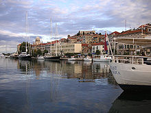 Šibenik, at the western terminus of the D58 road
 Trogir, at the eastern terminus of the D58 road
D58 is a state road in the central Dalmatia region of Croatia that provides access from the A1 motorway's Vrpolje interchange to the D8 state road, facilitating access from A1 motorway to Šibenik, Trogir and surrounding seaside resorts.[1] The road is 43.0 km (26.7 mi) long.[2]
The western terminus of the road is located in Šibenik port, near an interchange to the D8 state road. At its eastern terminus, the road connects once more to the D8 state road which serves as a parallel road to the D8 between Šibenik and Trogir, connecting to Rogoznica and Primošten.
The road, as well as all other state roads in Croatia, is managed and maintained by Hrvatske ceste, a state-owned company.[3]
Traffic volume
Traffic is regularly counted and reported by Hrvatske ceste, operator of the road.[4] Substantial variations between annual (AADT) and summer (ASDT) traffic volumes are attributed to the fact that the road serves as a D8 bypass, especially during summer season congestions.
D58 traffic volume Road Counting site AADT ASDT Notes  D58
D585320 Vrpolje west 4,290 4,725 Adjacent to Ž6108 junction. D585406 Donji Seget 3,173 4,567 Adjacent to D8 junction (Trogir). Road junctions
D58 major junctions/populated areas Type Slip roads/Notes 
Šibenik Port
The western terminus of the road.
Šibenik
Ž6106 to D33 state road through Šibenik. D8 to Vodice and Rogoznica.
Ž6108 to Jadrtovac. Donje Polje Vrpolje
Ž6109 to Ž6091 county road. D531 to A1 motorway Vrpolje interchange - to Šibenik and Zadar to the north, and to Split to the south.Čuklini Boraja Kneževići Ljubitovica Prapatnica
Ž6112 to Prgomet.Ž6129 to Bristvica and Blizna Donja. Seget Donji D8 to Marina and Kaštela.
The eastern terminus of the road.Sources
- ^ "Regulation on motorway markings, chainage, interchange/exit/rest area numbers and names" (in Croatian). Narodne novine. May 6, 2003. http://narodne-novine.nn.hr/clanci/sluzbeni/305463.html.
- ^ "Decision on categorization of public roads as state roads, county roads and local roads" (in Croatian). Narodne novine. February 17, 2010. http://narodne-novine.nn.hr/clanci/sluzbeni/2010_02_17_410.html.
- ^ "Public Roads Act" (in Croatian). Narodne novine. December 14, 2004. http://narodne-novine.nn.hr/clanci/sluzbeni/2004_12_180_3130.html.
- ^ "Traffic counting on the roadways of Croatia in 2009 - digest" (in English). Hrvatske ceste. May 1, 2010. http://www.hrvatske-ceste.hr/WEB%20-%20Legislativa/brojenje-prometa/CroDig2009.pdf.
Categories:- State roads in Croatia
- Split-Dalmatia County
- Šibenik-Knin County


Wikimedia Foundation. 2010.