- Oregon Route 202
-
For the former unsigned Highway 202, see Tampico-Lewisville Highway.
Oregon Route 202
Route information Maintained by ODOT Length: 45.98 mi (74.00 km) Major junctions West end:  US 101 in Astoria US 101 Business in Astoria
 OR 103 in Jewell
East end:  US 47 in Mist
Highway system Oregon highways
Routes • Highways←  OR 201
OR 203  →
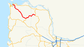
→Oregon Route 202 is an Oregon state highway which serves the northwestern corner of the state. It is part of the Nehalem Highway No. 102 (see Oregon highways and routes), and runs between the cities of Astoria and Mist.
Route description
The western terminus of Oregon Route 202 is an intersection with U.S. Route 101 in Astoria. OR 202 (concurrent for a short stretch with US 101 Business) continues southeast from there, along the eastern shore of Youngs Bay and the Youngs River. Soon after, it enters the valley of the Nehalem River, and continues southeast towards the community of Jewell. Leaving Jewell, it then continues east-northeast to the town of Mist, where OR 202 ends. The Nehalem Highway continues southeast from there, as Oregon Route 47.
Intersections with other highways
- U.S. Route 101 and U.S. Route 101 Business in Astoria
- Oregon Route 103 in Jewell
- Oregon Route 47 in Mist
Categories:- State routes in Oregon
- Transportation in Clatsop County, Oregon
- Transportation in Columbia County, Oregon


Wikimedia Foundation. 2010.