- Cuyo Archipelago
-
Cuyo Archipelago 
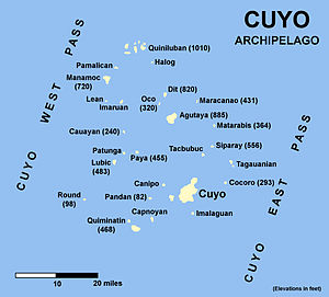
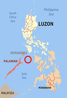
Cuyo Archipelago.Geography Location Sulu Sea Coordinates 10°51′N 121°01′E / 10.85°N 121.017°ECoordinates: 10°51′N 121°01′E / 10.85°N 121.017°E Archipelago Quiniluban Island group Country PhilippinesRegion IV-B MIMAROPA Province Palawan Municipality Cuyo Demographics Population 10,422 (as of 2000) The Cuyo Archipelago or Cuyo Islands, is a group of about 45 islands lying to the northeast of the Philippines island of Palawan.[1] It lies south of Mindoro and between Northern Palawan and Panay. It is centered around the largest island of the archipelago, the island of Cuyo, with an area of 22 square miles (57 km2) and is about 9 miles (14 km) long.
The 45 islands and islets of the archipelago form a total land area of 50 square miles (130 km2).[2] Cuyo is divided into two island groups. Up north is the Quiniluban group. To the south is the Cuyo group, where the centers of the three municipalities namely Cuyo, Agutaya, and Magsaysay are located.
Geologically, the islands are related to the main island of Palawan. They are positionned on the western edge of the Luzon Arc.[2] Cuyo island is volcanic. The northern islands of Quiniluban seem to be uplifted coral atolls, although the heights of some of the peaks strongly suggest volvanic uplift.[2] Many other islands of the group are purely corallian.[2]
Cuyo is divided in three municipalities, namely Cuyo, Agutaya, and Magsaysay:
- Cuyo, Palawan (southern and western part)
- Magsaysay, Palawan (eastern part)
- Agutaya, Palawan (northern part)
Altogether, about 40,000 people inhabit the Cuyo group of islands.
Some of the main island, or island groups, are (from north to south):
Islands
-
Manamoc island is located in the northwestern part of the Cuyo archipelago.
-
Pamalican island.
-
Agutaya island, and small Oco island in the forefront.
Notes
Municipalities Highly urbanized city Puerto Princesa
(Administratively independent from the province, but grouped under Palawan by the National Statistics Office)Categories:- Islands of the Philippines
- Philippines geography stubs
Wikimedia Foundation. 2010.


