Current River Cavern

Current River Cavern
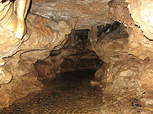
A passage in the cave before installation of the new boardwalk.

Current River Cavern is a show cave located in one mile west of Van Buren, MO on U.S. Highway 60. The cave is located inside Cave Spring Park.[1] The cave was first opened as a show cave in 1940 under the name "Cave Spring Onyx Caverns".[2]

Current River Cavern was formed exclusively by the stream that still runs through the cave; a rarity among Missouri caves. The cave is set in Eminence Dolomite.[3]

The commercial section of the cave extends 240 ft before ending at a flooded passage.[4] A 1996 survey reported 2,384 ft of passages extending far beyond the commercial section. The owners are seeking an alternative entrance and hope to open more of the cave to visitors in the future.

Current River Cavern is the first show cave to use all battery powered, wireless LED lights for illumination. The LED lights do not promote algae growth or harm cave life. In addition, the lack of wires through the cave creates a more safe and natural experience.

See Also

Caves of Missouri

References

  1. ^ Cave Spring Park, http://cavespringpark.com. Accessed 5/20/2011
  2. ^ Weaver, H. Dwight (2008). "Missouri Caves in History and Legend", University of Missouri Press
  3. ^ Bretz, J. Harlen (1956). "Caves of Missouri", State of Missouri
  4. ^ "Caves of the Current River Valley", Journal of the Missouri Speleological Survey, Volume 22, Numbers 3-4, Pages 82, 84.

External links


Wikimedia Foundation. 2010.

Игры ⚽ Нужна курсовая?

Look at other dictionaries:

  • river — river1 riverless, adj. riverlike, adj. /riv euhr/, n. 1. a natural stream of water of fairly large size flowing in a definite course or channel or series of diverging and converging channels. 2. a similar stream of something other than water: a… …   Universalium

  • South Nahanni River — Map of the South Nahanni River Origin Selwyn Mountains[1] Mouth …   Wikipedia

  • Onondaga Cave State Park — Coordinates: 38°3′40″N 91°13′38″W / 38.06111°N 91.22722°W / 38.06111; 91.22722 …   Wikipedia

  • Geography of Missouri — Physiographic map of Missouri (Legend) Courtesy USGS Missouri, a state near the geographical center of the United States, has three distinct physiographic divisions: * a north western upland plain or prairie region part of the Interior Plains… …   Wikipedia

  • List of Ontario parks — This is the list of all national and provincial parks in Ontario, Canada.National parksParks administered by Parks Canada: *Bruce Peninsula National Park *Fathom Five National Marine Park *Georgian Bay Islands National Park *Point Pelee National… …   Wikipedia

  • Parcs de l'Ontario — Parcs provinciaux de l Ontario Liste des parcs provinciaux de l Ontario[1]. Ils sont gérés par l agence Parcs Ontario, du ministère des Richesses naturelles. Sommaire : Haut A B C D E F G H I J K L M N O P Q R S T …   Wikipédia en Français

  • Parcs provinciaux de l'Ontario — Liste des parcs provinciaux de l Ontario[1]. Ils sont gérés par l agence Parcs Ontario, du ministère des Richesses naturelles. En 2008, il y avait 330 parcs provinciaux et réserves naturelles provinciales[2]. Ils couvrent une superficie de… …   Wikipédia en Français

  • Parcs provinciaux de l'ontario — Liste des parcs provinciaux de l Ontario[1]. Ils sont gérés par l agence Parcs Ontario, du ministère des Richesses naturelles. Sommaire : Haut A B C D E F G H I J K L M N O P Q R S T …   Wikipédia en Français

  • List of protected areas of Ontario — This is a list of protected areas of Ontario. Algonquin Provincial Park, Cache Lake …   Wikipedia

  • Orcus (Dungeons & Dragons) — Orcus Game background Title(s) Prince of the Undead, Prince of Undeath, The Blood Lord Home plane Abyss Power level Demon lord Alignment …   Wikipedia

Share the article and excerpts

Direct link
Do a right-click on the link above
and select “Copy Link”