Creuddyn, Ceredigion

Creuddyn, Ceredigion
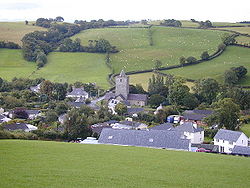
Llanfihangel-y-Creuddyn viewed from the north.

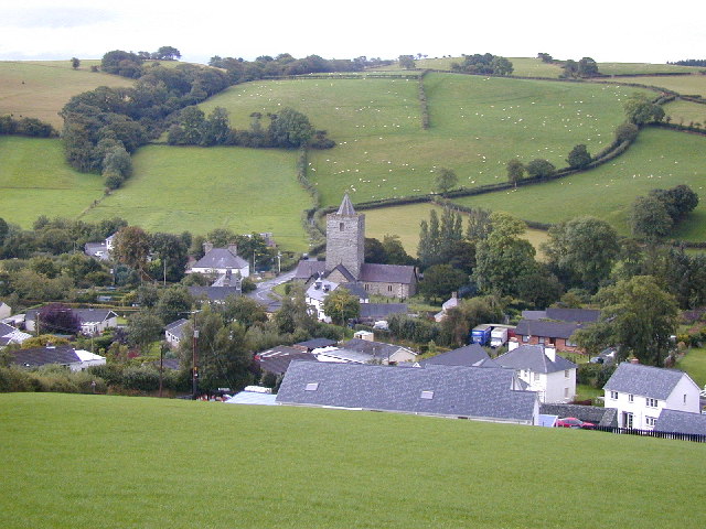
Creuddyn was a medieval commote (Welsh: cwmwd) and, later, a lordship in Ceredigion, Wales. It was located between the rivers Ystwyth and Rheidol,[1] and was one of the three commotes of Cantref Penweddig.[2] The name, of Old Welsh origin, probably refers to the Pen Dinas hill fort, anciently known as Dinas Maelor.[3][4] The natural centre of the commote was Llanfihangel y Creuddyn where five roads meet at the village. The name survives in the name of a rural community and church of the same name; however the modern community is much smaller than the medieval commote.

History

Several princes of Deheubarth ruled in medieval Kingdom of Ceredigion, including Creuddyn. Rhys ap Gruffydd's grandson Maelgwn Fychan (d. 1257) battled for control of the area; Gwenllian (d. 1254) died at Llanfihangel-y-Creuddyn. Either Maelgwn or his grandsons Llywelyn or Rhys may have been responsible for building the large 13th century church which still stands today.[4][5]

Footnotes

  1. ^ The Vaughans of Trawsgoed, p. 22
  2. ^ Archaeologia Cambrensis
  3. ^ A History of Wales from the Earliest Times
  4. ^ a b Ceredigion, A Wealth of History
  5. ^ Ymddiriedolaeth Archaeolegol Dyfed

References

Coordinates: 52°22′19″N 3°57′44″W / 52.37203°N 3.96231°W / 52.37203; -3.96231


Wikimedia Foundation. 2010.

Игры ⚽ Нужно решить контрольную?

Look at other dictionaries:

  • Creuddyn — may refer to: The Creuddyn Peninsula, in Conwy county borough Creuddyn, Ceredigion, a historic commote of Ceredigion Creuddyn, Rhos, a historic commote of Cantref Rhos in the kingdom of Gwynedd, and later of Caernarfonshire Llanfihangel y… …   Wikipedia

  • Ceredigion — For other uses, see Ceredigion (disambiguation). Ceredigion Sir Ceredigion Geography Area Total  % …   Wikipedia

  • Llanfihangel y Creuddyn — Infobox UK place country = Wales welsh name = Llanfihangel y Creuddyn constituency welsh assembly = official name = Llanfihangel y Creuddyn latitude = 52.369939 longitude = 3.961772 unitary wales = Ceredigion lieutenancy wales = Dyfed… …   Wikipedia

  • Comins Coch, Ceredigion — For the village near Llanbrynmair in Powys, see Commins Coch. Coordinates: 52°25′18″N 4°02′16″W / 52.4218°N 4.0379°W / 5 …   Wikipedia

  • Devil's Bridge, Ceredigion — The three bridges, looking downstream …   Wikipedia

  • List of places in Ceredigion — This is a list of towns and villages in the principal area of Ceredigion, Wales. See the list of places in Wales for places in other principal areas.compactTOC NOTOC A*Aberaeron *Aberarth *Aberffrwd *Aber meurig *Aberporth *Aberystwyth *Allt y… …   Wikipedia

  • Oakford, Ceredigion — Oakford (Welsh Derwen Gam) is a hamlet in the Welsh county of Ceredigion. It is some 5 miles (8 km) south of the coastal town of Aberaeron. External links www.geograph.co.uk : photos of Oakford and surrounding area Map sources for… …   Wikipedia

  • Llanfihangel — (Welsh for St Michael s Church) can refer to the following places in Wales:*Llanfihangel Aberbythych, Carmarthenshire *Llanfihangel y Creuddyn, Ceredigion *Llanfihangel ar Arth, Carmarthenshire *Llanfihangel Crucorney, Monmouthshire *Llanfihangel …   Wikipedia

  • Hafod Uchtryd — Infobox UK place country = Wales welsh name = Hafod Uchtryd constituency welsh assembly = official name = The Hafod Estate latitude = 52.369939 longitude = 3.961772 unitary wales = Ceredigion lieutenancy wales = Dyfed constituency westminster =… …   Wikipedia

  • Cribyn — For the mountain in the Brecon Beacons, see Cribyn (hill). Coordinates: 52°08′20″N 4°09′43″W / 52.139°N 4.162°W / 52.13 …   Wikipedia

Share the article and excerpts

Direct link
Do a right-click on the link above
and select “Copy Link”