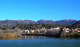
- Creu de Santos
-
Creu de Santos or Xàquera
Serra de Cardó from Tivenys; Creu de Santos is the highest summit on the right sideElevation 941 m (3,087 ft) Listing Mountains in Catalonia Location Location Tivenys, Benifallet (Baix Ebre)
Rasquera (Ribera d'Ebre),
 Catalonia
Range Serra de Cardó Coordinates 40°56′25.88″N 0°35′9.769″E / 40.9405222°N 0.58604694°ECoordinates: 40°56′25.88″N 0°35′9.769″E / 40.9405222°N 0.58604694°E Climbing Easiest route Walk Creu de Santos or Xàquera is the highest mountain of the Serra de Cardó range, Catalonia, Spain. The Serra de Cardó is part of the Massís de Cardó, Catalan Pre-Coastal Range. This mountain has an altitude of 941 metres above sea level.[1]
See also
- Cardó Massif
- Catalan Pre-Coastal Range
References
- ^ "Mapa Topogràfic de Catalunya". Institut Cartogràfic de Catalunya. http://www.icc.cat/vissir2/. Retrieved May 22, 2010..
Categories:- Mountains of Catalonia
- Catalonia geography stubs
Wikimedia Foundation. 2010.

