Sandon County

Sandon County
Sandon
New South Wales
Sandon NSW.PNG
Location in New South Wales
Lands administrative divisions around Sandon
Hardinge Hardinge Clarke
Hardinge Sandon Clarke
Inglis Vernon Vernon

Sandon County is one of the 141 Cadastral divisions of New South Wales. It is centred on Armidale, and also includes Uralla.

Sandon County was named in honour of Dudley Ryder, First Earl of Harrowby and Viscount Sandon (1762-1847).[1]

Parishes within this county

A full list of parishes found within this county; their current LGA and mapping coordinates to the approximate centre of each location is as follows:

Parish LGA Coordinates
Albert Armidale Dumaresq Council 30°23′54″S 151°30′04″E / 30.39833°S 151.50111°E / -30.39833; 151.50111 (Albert)
Arding Uralla Shire Council 30°33′54″S 151°30′04″E / 30.565°S 151.50111°E / -30.565; 151.50111 (Arding)
Armidale Armidale Dumaresq Council 30°30′54″S 151°41′04″E / 30.515°S 151.68444°E / -30.515; 151.68444 (Armidale)
Blacknote Uralla Shire Council 30°49′54″S 151°33′04″E / 30.83167°S 151.55111°E / -30.83167; 151.55111 (Blacknote)
Boorolong Armidale Dumaresq Council 30°19′54″S 151°34′04″E / 30.33167°S 151.56778°E / -30.33167; 151.56778 (Boorolong)
Butler Uralla Shire Council 30°29′54″S 151°36′04″E / 30.49833°S 151.60111°E / -30.49833; 151.60111 (Butler)
Clevedon Armidale Dumaresq Council 30°21′54″S 151°53′04″E / 30.365°S 151.88444°E / -30.365; 151.88444 (Clevedon)
Cooney Armidale Dumaresq Council 30°38′54″S 151°53′04″E / 30.64833°S 151.88444°E / -30.64833; 151.88444 (Cooney)
Dangarsleigh Uralla Shire Council 30°35′54″S 151°35′04″E / 30.59833°S 151.58444°E / -30.59833; 151.58444 (Dangarsleigh)
Davidson Armidale Dumaresq Council 30°24′24″S 151°52′04″E / 30.40667°S 151.86778°E / -30.40667; 151.86778 (Davidson)
Devon Uralla Shire Council 30°38′54″S 151°26′04″E / 30.64833°S 151.43444°E / -30.64833; 151.43444 (Devon)
Donald Armidale Dumaresq Council 30°26′54″S 151°44′04″E / 30.44833°S 151.73444°E / -30.44833; 151.73444 (Donald)
Dumaresq Armidale Dumaresq Council 30°24′54″S 151°34′04″E / 30.415°S 151.56778°E / -30.415; 151.56778 (Dumaresq)
Duval Armidale Dumaresq Council 30°25′54″S 151°38′04″E / 30.43167°S 151.63444°E / -30.43167; 151.63444 (Duval)
Eastlake Uralla Shire Council 30°48′54″S 151°37′04″E / 30.815°S 151.61778°E / -30.815; 151.61778 (Eastlake)
Elton Uralla Shire Council 30°29′54″S 151°31′04″E / 30.49833°S 151.51778°E / -30.49833; 151.51778 (Elton)
Enmore Armidale Dumaresq Council 30°42′54″S 151°48′04″E / 30.715°S 151.80111°E / -30.715; 151.80111 (Enmore)
Exmouth Armidale Dumaresq Council 30°19′54″S 151°38′04″E / 30.33167°S 151.63444°E / -30.33167; 151.63444 (Exmouth)
Falconer Guyra Shire Council 30°12′54″S 151°42′04″E / 30.215°S 151.70111°E / -30.215; 151.70111 (Falconer)
Ferryman Armidale Dumaresq Council 30°38′54″S 151°58′04″E / 30.64833°S 151.96778°E / -30.64833; 151.96778 (Ferryman)
Gara Armidale Dumaresq Council 30°31′54″S 151°46′04″E / 30.53167°S 151.76778°E / -30.53167; 151.76778 (Gara)
Gostwyck Uralla Shire Council 30°39′54″S 151°36′04″E / 30.665°S 151.60111°E / -30.665; 151.60111 (Gostwyck)
Hargrave Armidale Dumaresq Council 30°32′54″S 151°59′04″E / 30.54833°S 151.98444°E / -30.54833; 151.98444 (Hargrave)
Harnham Uralla Shire Council 30°44′54″S 151°28′04″E / 30.74833°S 151.46778°E / -30.74833; 151.46778 (Harnham)
Hillgrove Armidale Dumaresq Council 30°29′54″S 151°50′04″E / 30.49833°S 151.83444°E / -30.49833; 151.83444 (Hillgrove)
Kentucky Uralla Shire Council 30°44′54″S 151°24′04″E / 30.74833°S 151.40111°E / -30.74833; 151.40111 (Kentucky)
Lawrence Uralla Shire Council 30°44′54″S 151°40′04″E / 30.74833°S 151.66778°E / -30.74833; 151.66778 (Lawrence)
Merrigalah Armidale Dumaresq Council 30°42′54″S 151°53′04″E / 30.715°S 151.88444°E / -30.715; 151.88444 (Merrigalah)
Metz Armidale Dumaresq Council 30°32′54″S 151°53′04″E / 30.54833°S 151.88444°E / -30.54833; 151.88444 (Metz)
Mihi Uralla Shire Council 30°42′54″S 151°38′04″E / 30.715°S 151.63444°E / -30.715; 151.63444 (Mihi)
Salisbury Uralla Shire Council 30°44′54″S 151°33′04″E / 30.74833°S 151.55111°E / -30.74833; 151.55111 (Salisbury)
Saltash Uralla Shire Council 30°31′54″S 151°26′04″E / 30.53167°S 151.43444°E / -30.53167; 151.43444 (Saltash)
Sandon Uralla Shire Council 30°49′54″S 151°26′04″E / 30.83167°S 151.43444°E / -30.83167; 151.43444 (Sandon)
Saumarez Armidale Dumaresq Council 30°36′54″S 151°41′04″E / 30.615°S 151.68444°E / -30.615; 151.68444 (Saumarez)
Shasta Armidale Dumaresq Council 30°43′54″S 151°58′04″E / 30.73167°S 151.96778°E / -30.73167; 151.96778 (Shasta)
Sobraon Armidale Dumaresq Council 30°21′54″S 151°28′04″E / 30.365°S 151.46778°E / -30.365; 151.46778 (Sobraon)
Springmount Armidale Dumaresq Council 30°20′54″S 151°47′04″E / 30.34833°S 151.78444°E / -30.34833; 151.78444 (Springmount)
Tilbuster Armidale Dumaresq Council 30°20′54″S 151°43′04″E / 30.34833°S 151.71778°E / -30.34833; 151.71778 (Tilbuster)
Tiverton Armidale Dumaresq Council 30°38′54″S 151°46′04″E / 30.64833°S 151.76778°E / -30.64833; 151.76778 (Tiverton)
Uralla Uralla Shire Council 30°39′54″S 151°30′04″E / 30.665°S 151.50111°E / -30.665; 151.50111 (Uralla)
Urotah Armidale Dumaresq Council 30°29′54″S 151°56′04″E / 30.49833°S 151.93444°E / -30.49833; 151.93444 (Urotah)
Wentworth Guyra Shire Council 30°14′54″S 151°45′04″E / 30.24833°S 151.75111°E / -30.24833; 151.75111 (Wentworth)
Woolomombi Armidale Dumaresq Council 30°28′54″S 152°00′04″E / 30.48167°S 152.00111°E / -30.48167; 152.00111 (Woolomombi)
Woolomombi Armidale Dumaresq Council 30°29′54″S 152°00′04″E / 30.49833°S 152.00111°E / -30.49833; 152.00111 (Woolomombi)
Yarrowick Uralla Shire Council 30°26′54″S 151°26′04″E / 30.44833°S 151.43444°E / -30.44833; 151.43444 (Yarrowick)

References

  1. ^ Geographical Names Board of NSW

Wikimedia Foundation. 2010.

Игры ⚽ Поможем написать курсовую

Look at other dictionaries:

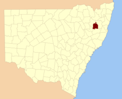
  • Sandon County, New South Wales — Infobox Australian cadastral name = Sandon state = New South Wales caption = Location in New South Wales near nw = Hardinge near n = Hardinge near ne = Clarke near e = Clarke near se = Vernon near s = Vernon near sw = Inglis near w =… …   Wikipedia

  • Sandon — may refer to:* Sandon, Essex * Sandon, Hertfordshire * Sandon, Staffordshire * Sandon, British Columbia * Sandon, Victoria * Sandon County, New South Wales * Sandon, ancient Hittite deity * Gotska Sandön, a Swedish islandPeople with the name… …   Wikipedia

  • Sandon Hall — is a 19th century country mansion, the seat of the Earl of Harrowby, at Sandon, Staffordshire, five miles north northeast of Stafford. It is a Grade II* listed building set in 400 acres of parkland.The Manor of Sandon came to Thomas Erdeswicke by …   Wikipedia

  • County of Talbot — Infobox Australian cadastral name = Talbot state = Victoria caption = Location in Victoria near nw = Gladstone near n = Gladstone near ne = Bendigo near e = Dalhousie near se = Bourke near s = Grant near sw = Ripon near w = GladstoneThe County of …   Wikipedia

  • County of Talbot, Victoria — Talbot Victoria Location in Victoria Lands administrative divisions around Talbot …   Wikipedia

  • The Sandon School — Infobox UK school name = The Sandon School size = latitude = 51.71572 longitude = 0.51644 dms = dms motto = motto pl = established = approx = closed = c approx = type = religion = president = head label = Headteacher head = Mr Jonathan Wincott r… …   Wikipedia

  • Chelmsford County High School for Girls — Chelmsford County High School main building Chelmsford County High School for Girls Motto Vitai Lampada Ferimus (We carry the lamp of life) Established 1906 …   Wikipedia

  • Colchester County High School — for Girls Motto Wisdom Giveth Life Established 1909 Type grammar academy Headteacher Mrs Gillian Marshall MSc Chair of Governors Allan Blundell Specialism …   Wikipedia

  • Clacton County High School — Motto Wider Aspirations, Higher Expectations Established 1928 Type Foundation school Principal Mr Jeff Brindle Assistant Principal Mr C J Hunt Specialism …   Wikipedia

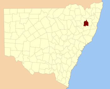
  • Inglis County, New South Wales — Infobox Australian cadastral name = Inglis state = New South Wales caption = Location in New South Wales near nw = Darling near n = Hardinge near ne = Sandon near e = Vernon near se = Vernon near s = Parry near sw = Parry near w = DarlingInglis… …   Wikipedia

Share the article and excerpts

Direct link
Do a right-click on the link above
and select “Copy Link”