Phillip County

Phillip County
Phillip
New South Wales
Phillip NSW.PNG
Location in New South Wales
Lands administrative divisions around Phillip
Bligh Brisbane Brisbane
Wellington Phillip Hunter
Wellington Roxburgh Hunter

Phillip County was one of the original Nineteen Counties in New South Wales and is now one of the 141 Cadastral divisions of New South Wales. It includes the area to the east of Mudgee and Gulgong. The Cudgegong River is the border to the south-west, and the Goulburn River the border to the north.

Phillip County was named in honour of Governor of New South Wales, Admiral Arthur Phillip (1738-1814.[1] The Electoral district of Phillip, Brisbane and Bligh was the first electoral district for the area, between 1856 and 1859.

Parishes within this county

A full list of parishes found within this county; their current LGA and mapping coordinates to the approximate centre of each location is as follows:

Parish LGA Coordinates
Arthur Mid-Western Regional Council 32°40′54″S 149°48′04″E / 32.68167°S 149.80111°E / -32.68167; 149.80111 (Arthur)
Bara Mid-Western Regional Council 32°35′54″S 149°49′04″E / 32.59833°S 149.81778°E / -32.59833; 149.81778 (Bara)
Barigan Mid-Western Regional Council 32°28′54″S 150°00′04″E / 32.48167°S 150.00111°E / -32.48167; 150.00111 (Barigan)
Bayly Mid-Western Regional Council 32°28′54″S 149°44′04″E / 32.48167°S 149.73444°E / -32.48167; 149.73444 (Bayly)
Boogledie Mid-Western Regional Council 32°32′54″S 149°43′04″E / 32.54833°S 149.71778°E / -32.54833; 149.71778 (Boogledie)
Botobolar Mid-Western Regional Council 32°29′54″S 149°47′34″E / 32.49833°S 149.79278°E / -32.49833; 149.79278 (Botobolar)
Budden Mid-Western Regional Council 32°26′54″S 150°05′04″E / 32.44833°S 150.08444°E / -32.44833; 150.08444 (Budden)
Bumberra Mid-Western Regional Council 32°33′54″S 149°38′04″E / 32.565°S 149.63444°E / -32.565; 149.63444 (Bumberra)
Burrumbelong Mid-Western Regional Council 32°26′54″S 150°03′04″E / 32.44833°S 150.05111°E / -32.44833; 150.05111 (Burrumbelong)
Bylong Mid-Western Regional Council 32°31′54″S 150°12′04″E / 32.53167°S 150.20111°E / -32.53167; 150.20111 (Bylong)
Coggan Mid-Western Regional Council 32°23′54″S 150°03′04″E / 32.39833°S 150.05111°E / -32.39833; 150.05111 (Coggan)
Comiala Mid-Western Regional Council 32°12′54″S 150°03′04″E / 32.215°S 150.05111°E / -32.215; 150.05111 (Comiala)
Coolcalwin Mid-Western Regional Council 32°46′54″S 150°08′04″E / 32.78167°S 150.13444°E / -32.78167; 150.13444 (Coolcalwin)
Cooyal Mid-Western Regional Council 32°25′54″S 149°44′04″E / 32.43167°S 149.73444°E / -32.43167; 149.73444 (Cooyal)
Cumbo Mid-Western Regional Council 32°22′54″S 149°53′04″E / 32.38167°S 149.88444°E / -32.38167; 149.88444 (Cumbo)
Dabee Mid-Western Regional Council 32°45′54″S 150°00′04″E / 32.765°S 150.00111°E / -32.765; 150.00111 (Dabee)
Derale Mid-Western Regional Council 32°36′54″S 149°44′04″E / 32.615°S 149.73444°E / -32.615; 149.73444 (Derale)
Dungeree Mid-Western Regional Council 32°41′54″S 149°53′04″E / 32.69833°S 149.88444°E / -32.69833; 149.88444 (Dungeree)
Eurundury Mid-Western Regional Council 32°28′54″S 149°39′04″E / 32.48167°S 149.65111°E / -32.48167; 149.65111 (Eurundury)
Fitzgerald Mid-Western Regional Council 32°26′54″S 150°01′04″E / 32.44833°S 150.01778°E / -32.44833; 150.01778 (Fitzgerald)
Galambine Mid-Western Regional Council 32°26′54″S 149°29′04″E / 32.44833°S 149.48444°E / -32.44833; 149.48444 (Galambine)
Growee Mid-Western Regional Council 32°35′54″S 150°03′04″E / 32.59833°S 150.05111°E / -32.59833; 150.05111 (Growee)
Gulgong Mid-Western Regional Council 32°22′54″S 149°34′04″E / 32.38167°S 149.56778°E / -32.38167; 149.56778 (Gulgong)
Guntawang Mid-Western Regional Council 32°21′54″S 149°29′04″E / 32.365°S 149.48444°E / -32.365; 149.48444 (Guntawang)
Hawkins Mid-Western Regional Council 32°37′54″S 149°54′04″E / 32.63167°S 149.90111°E / -32.63167; 149.90111 (Hawkins)
Kelgoola Mid-Western Regional Council 32°51′54″S 150°15′04″E / 32.865°S 150.25111°E / -32.865; 150.25111 (Kelgoola)
Kerrabee Muswellbrook Shire 32°26′54″S 150°18′04″E / 32.44833°S 150.30111°E / -32.44833; 150.30111 (Kerrabee)
Lee Mid-Western Regional Council 32°27′54″S 150°08′04″E / 32.465°S 150.13444°E / -32.465; 150.13444 (Lee)
Lennox Mid-Western Regional Council 32°14′54″S 149°51′04″E / 32.24833°S 149.85111°E / -32.24833; 149.85111 (Lennox)
Louee Mid-Western Regional Council 32°40′54″S 149°56′04″E / 32.68167°S 149.93444°E / -32.68167; 149.93444 (Louee)
Mcdonald Muswellbrook Shire 32°26′54″S 150°22′04″E / 32.44833°S 150.36778°E / -32.44833; 150.36778 (Mcdonald)
Mcdonald Muswellbrook Shire 32°32′54″S 150°16′04″E / 32.54833°S 150.26778°E / -32.54833; 150.26778 (Mcdonald)
Moolarben Mid-Western Regional Council 32°21′54″S 149°45′04″E / 32.365°S 149.75111°E / -32.365; 149.75111 (Moolarben)
Murrumbo Mid-Western Regional Council 32°20′54″S 150°15′04″E / 32.34833°S 150.25111°E / -32.34833; 150.25111 (Murrumbo)
Never Never Mid-Western Regional Council 32°46′54″S 150°14′04″E / 32.78167°S 150.23444°E / -32.78167; 150.23444 (Never Never)
Nullo Mid-Western Regional Council 32°35′54″S 150°10′04″E / 32.59833°S 150.16778°E / -32.59833; 150.16778 (Nullo)
Pomany Mid-Western Regional Council 32°44′54″S 150°18′04″E / 32.74833°S 150.30111°E / -32.74833; 150.30111 (Pomany)
Price Mid-Western Regional Council 32°27′54″S 149°50′04″E / 32.465°S 149.83444°E / -32.465; 149.83444 (Price)
Rumker Mid-Western Regional Council 32°41′54″S 150°02′04″E / 32.69833°S 150.03444°E / -32.69833; 150.03444 (Rumker)
Simpson Muswellbrook Shire 32°34′54″S 150°18′04″E / 32.58167°S 150.30111°E / -32.58167; 150.30111 (Simpson)
Tongbong Mid-Western Regional Council 32°43′54″S 149°56′04″E / 32.73167°S 149.93444°E / -32.73167; 149.93444 (Tongbong)
Wialdra Mid-Western Regional Council 32°21′54″S 149°39′04″E / 32.365°S 149.65111°E / -32.365; 149.65111 (Wialdra)
Widden Muswellbrook Shire 32°35′54″S 150°21′04″E / 32.59833°S 150.35111°E / -32.59833; 150.35111 (Widden)
Wilbertree Mid-Western Regional Council 32°27′54″S 149°35′04″E / 32.465°S 149.58444°E / -32.465; 149.58444 (Wilbertree)
Wilpinjong Mid-Western Regional Council 32°18′54″S 149°50′04″E / 32.315°S 149.83444°E / -32.315; 149.83444 (Wilpinjong)
Wollar Mid-Western Regional Council 32°20′54″S 149°58′04″E / 32.34833°S 149.96778°E / -32.34833; 149.96778 (Wollar)

References

  1. ^ Geographical Names Board of NSW

Wikimedia Foundation. 2010.

Игры ⚽ Нужна курсовая?

Look at other dictionaries:

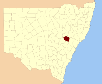
  • Phillip County, New South Wales — Infobox Australian cadastral name = Phillip state = New South Wales caption = Location in New South Wales near nw = Bligh near n = Brisbane near ne = Brisbane near e = Hunter near se = Hunter near s = Roxburgh near sw = Wellington near w =… …   Wikipedia

  • Phillip DeFreitas — Personal information Full name Phillip Anthony Jason DeFreitas Born 18 February 1966 (1966 02 18) (age 45) Scotts Head, Dominica Nickname Daffy Height 5 ft 11 in (1.80 m) Batting style …   Wikipedia

  • Phillip Mitchell Landrum — (* 10. September 1907 in Martin, Stephens County, Georgia; † 19. November 1990 in Jasper, Georgia) war ein US amerikanischer Politiker und vertrat den Bundesstaat Georgia als Abgeordneter im US Repräsentantenhaus. Werdegang Phillip Mitchell… …   Deutsch Wikipedia

  • Phillip van Dyke — Phillip Glenn Van Dyke (* 13. Juni 1984 in San Francisco) ist ein US amerikanischer Schauspieler und Synchronsprecher. Van Dyke wuchs in Marin County, Kalifornien auf. Seine Schauspielkarriere startete er mit einem Werbespot für eine… …   Deutsch Wikipedia

  • Phillip Willis — Saltar a navegación, búsqueda Phillip LaFrance Willis (2 de agosto, 1918, Kaufman County, Texas – 27 de enero, 1995, Dallas (Texas).[1] [2] [3] fue un testigo …   Wikipedia Español

  • Phillip Van Dyke — Phillip Glenn Van Dyke (* 13. Juni 1984 in San Francisco) ist ein US amerikanischer Schauspieler und Synchronsprecher. Van Dyke wuchs in Marin County, Kalifornien auf. Seine Schauspielkarriere startete er mit einem Werbespot für eine… …   Deutsch Wikipedia

  • Phillip Willis — Phillip LaFrance Willis (2 August 1918, Kaufman County, Texas – 27 January 1995, Dallas, Texas) [Ancestry.com. Texas Death Index, 1903 2000 [database on line] . Provo, UT, USA: The Generations Network, Inc., 2006.] [Social Security Death Index.]… …   Wikipedia

  • Phillip Norris Armstrong — Phillip Norris Army Armstrong Army Armstrong Sport(s) College football Current position Team Carroll College (Wisconsin) Biographical details …   Wikipedia

  • Phillip M. Landrum — Phillip Mitchell Landrum (* 10. September 1907 in Martin, Stephens County, Georgia; † 19. November 1990 in Jasper, Georgia) war ein US amerikanischer Politiker und vertrat den Bundesstaat Georgia als Abgeordneter im US Repräsentantenhaus.… …   Deutsch Wikipedia

  • Phillip Inzerillo — (born March 4, 1984 in Alhambra, California) was a trombone player for the Orange County based third wave ska band Suburban Legends. He joined the band in late 2005 to play trombone in the place of Ryan Dallas Cook who died on October 19 2005 in… …   Wikipedia

Share the article and excerpts

Direct link
Do a right-click on the link above
and select “Copy Link”