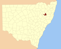
Inglis County

Inglis County
Inglis
New South Wales
Inglis NSW.PNG
Location in New South Wales
Lands administrative divisions around Inglis
Darling Hardinge Sandon
Darling Inglis Vernon
Parry Parry Vernon

Inglis County is one of the 141 Cadastral divisions of New South Wales. It contains Tamworth and Bendemeer.

Inglis County was named in honour of Major-General, Sir John Eardley Wilmot Inglis (1814-1862).[1]

Parishes within this county

A full list of parishes found within this county; their current LGA and mapping coordinates to the approximate centre of each location is as follows:

Parish LGA Coordinates
Attunga Tamworth Regional Council 30°55′54″S 150°51′04″E / 30.93167°S 150.85111°E / -30.93167; 150.85111 (Attunga)
Bendemeer Tamworth Regional Council 30°51′54″S 150°11′04″E / 30.865°S 150.18444°E / -30.865; 150.18444 (Bendemeer)
Bloomfield Tamworth Regional Council 30°52′54″S 150°39′04″E / 30.88167°S 150.65111°E / -30.88167; 150.65111 (Bloomfield)
Bubbogullion Tamworth Regional Council 30°52′54″S 150°46′04″E / 30.88167°S 150.76778°E / -30.88167; 150.76778 (Bubbogullion)
Burdekin Tamworth Regional Council 30°51′54″S 150°50′04″E / 30.865°S 150.83444°E / -30.865; 150.83444 (Burdekin)
Burke Tamworth Regional Council 30°58′54″S 151°17′04″E / 30.98167°S 151.28444°E / -30.98167; 151.28444 (Burke)
Congi Walcha Council 30°54′54″S 151°25′04″E / 30.915°S 151.41778°E / -30.915; 151.41778 (Congi)
Danglemah Tamworth Regional Council 30°59′54″S 151°10′04″E / 30.99833°S 151.16778°E / -30.99833; 151.16778 (Danglemah)
Gill Tamworth Regional Council 30°52′54″S 150°56′04″E / 30.88167°S 150.93444°E / -30.88167; 150.93444 (Gill)
Haning Tamworth Regional Council 30°46′54″S 151°05′04″E / 30.78167°S 151.08444°E / -30.78167; 151.08444 (Haning)
Looanga Tamworth Regional Council 30°44′54″S 151°20′04″E / 30.74833°S 151.33444°E / -30.74833; 151.33444 (Looanga)
Moonbi Tamworth Regional Council 31°01′54″S 151°02′04″E / 31.03167°S 151.03444°E / -31.03167; 151.03444 (Moonbi)
Muluerindie Tamworth Regional Council 30°54′54″S 151°15′04″E / 30.915°S 151.25111°E / -30.915; 151.25111 (Muluerindie)
Perry Tamworth Regional Council 30°56′54″S 151°05′04″E / 30.94833°S 151.08444°E / -30.94833; 151.08444 (Perry)
Pringle Tamworth Regional Council 30°38′54″S 151°05′04″E / 30.64833°S 151.08444°E / -30.64833; 151.08444 (Pringle)
Retreat Tamworth Regional Council 30°37′54″S 151°08′04″E / 30.63167°S 151.13444°E / -30.63167; 151.13444 (Retreat)
Scott Walcha Council 31°00′54″S 151°23′04″E / 31.015°S 151.38444°E / -31.015; 151.38444 (Scott)
South Burke Tamworth Regional Council 31°01′54″S 151°15′04″E / 31.03167°S 151.25111°E / -31.03167; 151.25111 (South Burke)
South Burke Tamworth Regional Council 31°02′54″S 151°16′04″E / 31.04833°S 151.26778°E / -31.04833; 151.26778 (South Burke)
Tamworth Tamworth Regional Council 31°04′54″S 150°59′04″E / 31.08167°S 150.98444°E / -31.08167; 150.98444 (Tamworth)
Tara Tamworth Regional Council 30°50′54″S 151°19′04″E / 30.84833°S 151.31778°E / -30.84833; 151.31778 (Tara)
Winton Tamworth Regional Council 30°43′54″S 151°10′04″E / 30.73167°S 151.16778°E / -30.73167; 151.16778 (Winton)
Woolomol Tamworth Regional Council 31°01′54″S 150°55′04″E / 31.03167°S 150.91778°E / -31.03167; 150.91778 (Woolomol)

References

  1. ^ Geographical Names Board of NSW

Wikimedia Foundation. 2010.

Игры ⚽ Нужно сделать НИР?

Look at other dictionaries:

  • Inglis County, New South Wales — Infobox Australian cadastral name = Inglis state = New South Wales caption = Location in New South Wales near nw = Darling near n = Hardinge near ne = Sandon near e = Vernon near se = Vernon near s = Parry near sw = Parry near w = DarlingInglis… …   Wikipedia

  • County Ground, Swindon — County Ground Location County Road, Swindon SN1 2ED Coordinates …   Wikipedia

  • Inglis, Florida — Infobox Settlement official name = Inglis, Florida other name = native name = nickname = settlement type = Town motto = imagesize = image caption = flag size = image seal size = image shield = shield size = image blank emblem = blank emblem type …   Wikipedia

  • Inglis, Charles — ( 1734 1816 )    first Anglican bishop to serve outside the United Kingdom    Charles Inglis was born at Glencolumbkille, County Donegal, Ireland, the son of an Anglican minister. At age 20, inglis moved to Lancaster, Pennsylvania, where he… …   Encyclopedia of Protestantism

  • Inglis, Charles — ▪ Canadian bishop born 1734, Glencolumbkille, County Donegal, Ire. died Feb. 24, 1816, near Halifax, Nova Scotia, Can.  Canadian clergyman and educator who became the first Anglican bishop of Nova Scotia.       Inglis went to North America and… …   Universalium

  • List of county roads in Levy County, Florida — County road shields used in Florida Highway names County: County Road X (CR X) System links Florida State an …   Wikipedia

  • Bob Inglis — Infobox Congressman name = Bob Inglis date of birth = birth date and age|1959|10|11 place of birth = Savannah, Georgia state = South Carolina district = 4th term start =January 3, 2005 preceded = Jim DeMint term start2=January 3, 1993 term… …   Wikipedia

  • Bob Inglis — Robert Durden „Bob“ Inglis (* 11. Oktober 1959 in Savannah, Georgia) ist ein US amerikanischer Politiker. Zwischen 1993 und 1999 vertrat er den Bundesstaat South Carolina im US Repräsentantenhaus. Dieses Mandat übte er von 2005 bis 2011 erneut… …   Deutsch Wikipedia

  • Columbia County, Oregon — Location in the state of Oregon …   Wikipedia

  • Fred Inglis — is Emeritus Professor of Cultural Studies at the University of Sheffield in the UK. Previously Professor of Cultural Studies at the University of Warwick, he has been a member of the School of Social Science at the Institute for Advanced Study,… …   Wikipedia

Share the article and excerpts

Direct link
Do a right-click on the link above
and select “Copy Link”