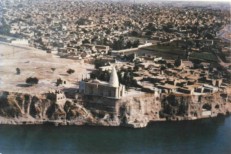
Dez River

Dez River
Dez

Rudband Shrine in the bank of Dez River
Mouth Karun River
Basin countries Iran

The Dez River (Persian: دز), the ancient Coprates[1] (Greek: Κοπράτης or Κοπράτας), is a tributary of the Karun River and is 400 km long. It is the site of the Dez Dam.

It is believed that a fortress protected a strategic bridge across the river at Dezful, whence the name, although no trace of this castle remains. The old part of the city adjacent to the bridge is known as the Qaleh (castle).

References

  1. ^ Edward Anson, Eumenes of Cardia: A Greek among Macedonians (Brill Academic Publishers, 2004), p. 166.

Coordinates: 32°54′05″N 48°43′52″E / 32.9014°N 48.7311°E / 32.9014; 48.7311


Wikimedia Foundation. 2010.

Игры ⚽ Поможем сделать НИР

Look at other dictionaries:

  • Dez Dam — Dez Dam …   Wikipedia

  • Dez — geographical name river 250 miles (402 kilometers) W Iran flowing S to the Karun …   New Collegiate Dictionary

  • Karkheh River — The Karkheh or Karkhen (known as the Gihon[citation needed] one of the four rivers of Eden/Paradise to the Bible and as the Choaspes[1] in ancient times; also called Eulæus; Hebrew: אולי Ulai[2]) is a river in Khūzestān Province, Iran (ancient… …   Wikipedia

  • Kārūn River — River, southwestern Iran. A tributary of the Shatt al Arab, it rises in the Bakhtīārī Mountains and flows through mountains for 515 mi (829 km). The Ḥaffār Channel, dug in 986, changed its course, causing frontier disputes between Iran and the… …   Universalium

  • Des Plaines River — Typical section of Des Plaines River in Lake County, Illinois. Origin West of Kenosha, Kenosha County, Wisconsin …   Wikipedia

  • Dezful — For the administrative subdivision, see Dezful County. Dezful دزفول   city   Rudband Shrine and the City along the Dez Rive …   Wikipedia

  • Dezful — [dez fo͞ol′] city in W Iran: pop. 181,000 * * * ▪ Iran also spelled  Dizfūl   city, southwestern Iran. It lies on the high left bank of the Dez River, 469 feet (143 metres) in elevation, close to the foothills of the Zagros Mountains. The name,… …   Universalium

  • Список самых высоких плотин в мире — Естественная плотина высотой 567 м на реке Мургаб и Сарезское озеро (Таджикистан) …   Википедия

  • Khūzestān Province — Infobox Iran Province province name = Khūzestān ostan name = خوزستان loc capital = Ahvaz latd = 31.3273 longd = 48.6940 area = 64,055 pop = 4,345,607 pop year = 2005 pop density = 67.8 sub provinces = 18 languages= Persian Bakhtiari Arabic Luri… …   Wikipedia

  • Koohrang — Kuhrang also known as Koohrang is the name of a river, originating in the Zagros mountains of western Iran, which joins the Dez River to form the Karun, Iran s largest (by volume) river. A series of tunnels (Kuhrang Tunnels) have been built since …   Wikipedia

Share the article and excerpts

Direct link
Do a right-click on the link above
and select “Copy Link”