- Cooplacurripa River
-
Cooplacurripa River 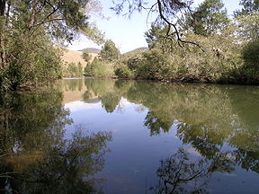
Origin New South Wales Mouth Confluence with Nowendoc River Basin countries Australia Length 75 km Source elevation 1,260 metres Mouth elevation 150 metres The Cooplacurripa River is a river, approximately 75 kilometres long, on the Northern Tablelands of New South Wales, Australia.
It rises at an approximate elevation of 1,260 metres on the slopes of the Great Dividing Range about 3.5 kilometres north-east of Riamukka. The Cooplacurripa River flows generally south-east until it is joined by the Walcrow River and Mummel River before its confluence with the Nowendoc River about 33 km south-east of Nowendoc.
Country along Cooplacurripa River is a grazing area used principally for the rearing of beef cattle. The 22,560 hectare cattle station, "Cooplacurripa", which is situated on the Cooplacurripa River was formerly owned by the Australian Agricultural Company (AACo).[1] In the 1929 flood a man lost his life whilst crossing floodwaters at Cooplacurripa.[2]
The Cooplacurripa River is within the boundaries of Walcha Local Government Area and Hawes County.[3]
The Northern NSW Trout Waters listing includes the whole of the waters of the Cooplacurripa River, its creeks and tributaries upstream from its junction with, and including, the Mummel River.[4]
See also
References
- ^ ABC News Retrieved on 2009-8-5
- ^ Manning River Four Record Floods Retrieved on 2009-8-5
- ^ GNB extract Retrieved on 2009-8-5
- ^ Fisheries info Retrieved on 2009-8-5
- "List of placenames ASSIGNED as RIVERs". Geographical Names Register (GNR) of NSW. Geographical Names Board of New South Wales. http://www.gnb.nsw.gov.au/name_search?transaction=savefile&placename=&status=ASSIGNED&designation=RIVER&lga=None&map=&parish=. Retrieved 2008-06-07.
Categories:- New South Wales geography stubs
- Rivers of New South Wales

Wikimedia Foundation. 2010.