- Conductivity, temperature, depth
-
A CTD profiler is an essential instrument of physical and biological oceanographic field research. Operated from a ship, it greatly contributes to our understanding of ocean dynamics by gathering information on the distribution and variation of the ocean's properties. CTD is an acronym for Conductivity, Temperature, and Depth, the three main parameters that the instrument measures.
Contents
Description
Measured properties
The instrument is a cluster of sensors that measure continuous data of depth, salinity, and temperature, from which measurements of density can be derived. Sensors commonly scan at a rate of 24 Hz. Depth measurements are derived from measurement of hydrostatic pressure, and salinity is measured from electrical conductivity.[1] Sensors are arranged inside a metal housing, the metal used for the housing determining the depth to which the CTD can be lowered. Titanium housings allow sampling of the water column down to more than 10,000 m (~34,000 ft) [2]. Other sensors may be added to the cluster, including some that measure chemical or biological parameters, such as dissolved oxygen and chlorophyll fluorescence, the latter an indication of the concentration of microscopic photosynthetic organisms (phytoplankton) contained in the water.
Water sampling
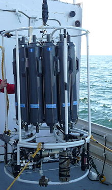
Often the sensors are mounted on a carousel of vertically mounted water samplers, also called a rosette. Twelve to twenty water bottles[3], such as Niskin or GO-FLOW [4] may be used. The closing of the sampling bottles is triggered from an onboard computer, thus water samples can be obtained from specific depths, from which biological and chemical parameters can be measured. Often analyses of the water samples are used in the calibration of the sensors. [5]
Deployment
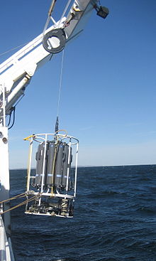
Deployment of the CTD is made from the deck of the research vessel. The instrument is lowered into the water in what is called the downcast to a determined depth or to a few meters above the ocean floor, generally at a rate of about 0.5 m s-1. Most of the time a conducting wire cable is attached to the CTD frame connecting the CTD to an onboard computer, and allows instantaneous uploading and real time visualization of the collected data on the computer screen. The water column profile of the downcast is often used to determine the depths at which the CTD will be stopped on its way back to the surface, or the upcast, to collect the water samples.
Technological development
The CTD system was developed by Neil Brown, of the Woods Hole Oceanographic Institution, to overcome the limitations of an earlier similar system also developed by Brown, called an STD. The improvement was made possible thanks to increased reliability and reduced cost of computer technology. [6]
Advantages and Limitations
The advantage of CTD casts is the acquisition of high resolution data. The limitation of CTD sampling is that only a point in space (the sampling site) can be sampled at one time, and many casts, which are costly and time consuming, are needed to acquire a broad picture of the marine environment of interest. From the information gathered during CTD casts, however, scientists can investigate how physical parameters are related, for example, to the observed distribution and variation of organisms that live in the ocean, thus deepening our understanding of the processes that govern ocean life.
Notes
- ^ Pickard and Emery 1990, p 100
- ^ http://www.seabird.com/products/profilers.htm
- ^ Pickard and Emery 1990, p 96
- ^ http://cis.whoi.edu/science/bcodmo/instrument.cfm
- ^ Pickard and Emery 1990, p 100
- ^ Baker 1981, pp 416-418
References
- Baker D. J. 1981 "Ocean instruments and experiment design" Chapter 14 pp 416-418, available at http://ocw.mit.edu/resources/res-12-000-evolution-of-physical-oceanography-spring-2007/part-3/wunsch_chapter14.pdf
- Pickard George L. and William J. Emery "Descriptive Physical Oceanography, An introduction" 5th ed., Butterworth-Heineman (Elsevier Science): 1990
Categories:
Wikimedia Foundation. 2010.


