- Comox Glacier
-
Comox Glacier 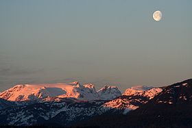
Comox Glacier on a February MorningElevation 1,960 m (6,430 ft) Location Location Vancouver Island, British Columbia, Canada Range Vancouver Island Ranges Coordinates 49°32′58″N 125°21′12″W / 49.54944°N 125.35333°WCoordinates: 49°32′58″N 125°21′12″W / 49.54944°N 125.35333°W Topo map NTS 92/F11 Climbing First ascent George Kinney, Alfred McNevin, James Tremlett and Harold Banks, August 1922[1] The Comox Glacier is a glacier on Vancouver Island, British Columbia, Canada, located 30 km (19 mi) southwest of Courtenay and 1 km (0.62 mi) west of Argus Mountain.
The highest elevation of the Comox Glacier, 1,960 m (6,430 ft), refers to a rocky outcrop on the north side of the glacier. Lacking an official name, it is referred to as the Comox Glacier summit.
The Comox Glacier is a member of the Vancouver Island Ranges which in turn form part of the Insular Mountains.[2]
Contents
History
The name Comox Glacier comes from the name of the K'ómoks First Nation who inhabit the area. They refer to the mountain by the name Kwénis, which means "whale". This name comes from a traditional account of the Great Flood: a whale was said to be trapped up on the mountain when the flood receded. In the early 1900s, the glacier was known as Dome Glacier. The name Comox Glacier was officially adopted in 1939, at the suggestion of the Comox & District Mountaineering Club.[3]
Access
There are two direct routes to the Comox Glacier:
1. Comox Glacier Trail (aka Frog's Pond Route) - the most direct route to the Comox Glacier. It begins where Datsio Creek meets Comox Creek. The route initially heads up the valley towards Century Sam Lake, but quickly gains the ridge to the west. The route follows the height of the ridge up to Lone Tree Pass, and on to the south flanks of the Comox Glacier.
2. Kookjai Route - this route starts at Cougar Lake, near the Comox Gap. It traverse over Kookjai Mountain and Black Cat Mountain before meeting up with the Comox Glacier Trail at Lone Tree Pass.
Alternatively, the Comox Glacier can be accessed by traversing fom Argus Mountain to the west, or climbing up from Milla Lake to the north.
See also
References
- ^ The Comox Glacier: And its Early Climbing History, Lindsay Elms, 2001
- ^ Comox Glacier
- ^ "Comox Glacier". BC Geographical Names. http://apps.gov.bc.ca/pub/bcgnws/names/37987.html.
Categories:- Vancouver Island Ranges
- Mid Vancouver Island
- Glaciers of British Columbia
- British Columbia Coast geography stubs

Wikimedia Foundation. 2010.