- Comb Ridge
-
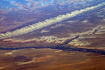
 Comb Ridge from the air, above Bluff Utah and the San Juan River. Photo by Doc Searls.
Comb Ridge is a linear north to south-trending monocline nearly 120 miles long in southeast Utah and Arizona. Composed of Jurassic-age Navajo Sandstone, it displays massive eolian cross-bedding.
The Navajo name tséyíkʼáán translates to Rock Extends in the Form of a Narrow Edge in English[1]. Traces of the Ancient Pueblo Peoples culture can be found along the southern part of the ridge where it follows Chinle Wash. The Macomb and Hayden expeditions in 1869 and 1874–1876, respectively, were the first to publish maps and descriptions of this feature[2]. The ridge and adjacent Butler Wash were given their current names in 1884, by P. Holmann.[2] [3] [4]
Gallery
See also
- Posey War
- Trail of the Ancients
- Anasazi State Park Museum
- Pueblo III Era
References
- ^ Linford, Laurence D. Navajo Places: History, Legend, Landscape, University of Utah Press, Salt Lake City, UT 2000
- ^ a b Gregory, H.E., 1938, The San Juan Country, a Geographic and Geologic Reconnaissance of Southeastern Utah: U.S. Geological Survey Professional Paper 188, 123 p.
- ^ Roberts, David (2006-03). "Hiking Comb Ridge". National Geographic Adventure Magazine. http://www.nationalgeographic.com/adventure/0603/features/comb_ridge.html. Retrieved 2009-05-06.
- ^ Roberts, David (2005-06-30). Sandstone Spine: Seeking the Anasazi on the First Traverse of the Comb Ridge. Mountaineers Books. ISBN 1594850054.
Coordinates: 37°25′39″N 109°38′47″W / 37.4275°N 109.64639°W
Categories:- Geography of Apache County, Arizona
- Geography of Navajo County, Arizona
- Geography of San Juan County, Utah
- Geography of Arizona
- Geography of Utah
- Cliff dwellings
- Arizona geography stubs
- Utah geography stubs
Wikimedia Foundation. 2010.


