- Col du Noyer
-
Col du Noyer 
Col du Noyer, seen from Champsaur.Elevation 1,664 m (5,459 ft) Traversed by D 17 Location Location Hautes-Alpes,  France
Range Alps Coordinates 44°41′31″N 5°59′7″E / 44.69194°N 5.98528°ECoordinates: 44°41′31″N 5°59′7″E / 44.69194°N 5.98528°E Col du Noyer (el. 1664 m.) is a high mountain pass in the Alps in the department of Hautes-Alpes in France.
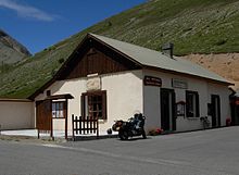
Napoléon's refuge at col du Noyer.
Appearances in Tour de France
The pass was first included in the Tour de France in 1970 and has since featured 4 times, most recently in 2010. [1]
Year Stage Category Leader at the summit 2010 10 2  Mario Aerts (BEL)
1982 15 2  Pascal Simon (FRA)
1971 11 2  Luis Ocaña (ESP)
1970 13 1  Raymond Delisle (FRA)
See also
- List of highest paved roads in Europe
- List of mountain passes
References
- ^ "Le col du Noyer dans le Tour de France". ledicodutour.com. http://ledicodutour.perso.sfr.fr/montagnes/cols__n/noyer.htm. Retrieved 14 July 2010.
Categories:- Mountain passes of France
- Mountain passes of the Alps
- Hautes-Alpes geography stubs
Wikimedia Foundation. 2010.

