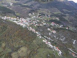
- Col, Slovenia
-
Col Location in Slovenia Coordinates: 45°52′48.44″N 14°0′7″E / 45.8801222°N 14.00194°ECoordinates: 45°52′48.44″N 14°0′7″E / 45.8801222°N 14.00194°E Country  Slovenia
Region Goriška Municipality Ajdovščina Area - Total 2.62 km2 (1 sq mi) Elevation 611.3 m (2,006 ft) Population (2002) - Total 498 [1] Col (Italianized: Zolla) is a settlement on the edge of a karst plateau overlooking the Vipava Valley in the Ajdovščina Municipality in the Littoral region of Slovenia. A Roman road lead through the settlement. Its location overlooking the valley on the main route leading inland, was utilised in the Middle Ages and later as a check point between the Littoral region and Carniola. Indeed the name of the settlement Col comes from the German: Zoll, meaning toll or customs duty.[2]
The Parish Church in the settlement is dedicated to Saint Leonard and belongs to the Diocese of Koper.[3]
References
External links
Ajdovščina Settlements Administrative centre:Ajdovščina
Batuje, Bela, Brje, Budanje, Cesta, Col, Črniče, Dobravlje, Dolenje, Dolga Poljana, Gaberje, Gojače, Gozd, Grivče, Kamnje, Kovk, Kožmani, Križna gora, Lokavec, Male Žablje, Malo Polje, Malovše, Otlica, Plače, Planina, Podkraj, Potoče, Predmeja, Ravne, Selo, Skrilje, Stomaž, Šmarje, Tevče, Ustje, Velike Žablje, Vipavski Križ, Višnje, Vodice, Vrtovče, Vrtovin, Zavino, Žagolič, ŽapužeLandmarks Vipavski Križ Church, Church of John the Baptist, Trilek CastleNotable people Categories:- Populated places in the Municipality of Ajdovščina
- Goriška statistical region geography stubs
Wikimedia Foundation. 2010.


