- Clifton Bridge (Nottingham)
-
Clifton Bridge 
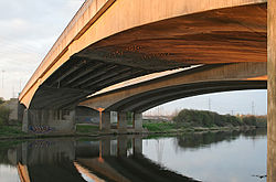
Clifton Bridge from the south bank of the River TrentCrosses River Trent Total length 275ft Opened 5 June 1958 Coordinates 52°55′30″N 1°09′57″W / 52.9251°N 1.1658°WCoordinates: 52°55′30″N 1°09′57″W / 52.9251°N 1.1658°W Clifton Bridge is a road bridge spanning the River Trent and carrying the A52 road to the west of the city of Nottingham, in the county of Nottinghamshire, UK.
It was completed and opened to traffic in March 1958 and is constructed of pre-stressed concrete. It is the next upstream road bridge from Trent Bridge.
One of the bridges over the Trent at Clifton Bridge includes a section of the former B680 (which followed the route into Nottingham now used by the A453). The 275ft east bridge was formally opened on 5 June 1958 by Princess Alexandra, The Honourable Lady Ogilvy.
With the addition of the west bridge the crossing became dual-carriageway as the A614 as part of a 11⁄4-mile (2.0 km) £3.2 million section (£31,473,621 as of 2011),[1], opening in 1972.
General references
Finch RM & Goldstein A (Vol.12, Is.3, March 1959). Clifton Bridge, Nottingham: Initial Design Studies & Model Test. Inst. of Civil Engineers.
- ^ UK CPI inflation numbers based on data available from Lawrence H. Officer (2010) "What Were the UK Earnings and Prices Then?" MeasuringWorth.
Next road crossing upstream River Trent Next road crossing downstream Harrington Bridge Clifton Bridge
A52 roadTrent Bridge
(A60 road)Categories:- East Midlands building and structure stubs
- United Kingdom bridge (structure) stubs
- Bridges in Nottingham
- Bridges across the River Trent
- Bridges completed in 1958
Wikimedia Foundation. 2010.
