Claremont Pier

Claremont Pier
Claremont Pier

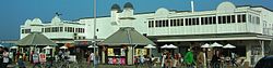
The Claremont Pier looking towards front.
Official name Claremont Pier
Type Pleasure Pier
Design D. Fox
Owner David Scott and Family
Total length 218 m
Opening date 1903
Coordinates 52°27′57″N 1°44′47″E / 52.4657°N 1.7464°E / 52.4657; 1.7464Coordinates: 52°27′57″N 1°44′47″E / 52.4657°N 1.7464°E / 52.4657; 1.7464

The Claremont Pier is a traditional seaside pier in Lowestoft in the English county of Suffolk.[1]

History

The pier was constructed in 1902/03 and used originally as a mooring for Belle steamers.[2] It was designed by D. Fox and was originally 181.8 m in length and 10.9 m in width. In 1912, it was extended to a length of 230.3 m. In World War Two, it was used as an army base until 1948. After repair in the 1950s, a storm in 1962 washed a section of it away, reducing its length to 218 meters.[1]

In the 1990s the pier was taken over by the Scott family and, despite restoration work on the shoreward end, much of the pier remains in need of restoration.[1][2]

References

  1. ^ a b c The Heritage Trail
  2. ^ a b History of Lowestoft Claremont Pier, National Piers Society. Retrieved 2011-06-09.

External links


Wikimedia Foundation. 2010.

Игры ⚽ Поможем написать реферат

Look at other dictionaries:

  • Lowestoft — infobox UK place country = England official name= Lowestoft latitude= 52.48 longitude= 1.75 population = 57,746 (2001 Census) shire district= Waveney region= East of England shire county = Suffolk constituency westminster= Waveney post town=… …   Wikipedia

  • Key System — The Key System (or Key Route) was a privately owned company which provided mass transit in the cities of Oakland, Berkeley, Alameda [ [http://findarticles.com/p/articles/mi qn4176/is 20030621/ai n14551761 Old Alameda s transit system was less… …   Wikipedia

  • Manhattanville — Die 125th Street Station an der Kreuzung von Broadway und 125th Street Manhattanville ist ein Viertel im New Yorker Stadtbezirk Manhattan und der gleichnamigen Insel. Inhaltsverzeichnis …   Deutsch Wikipedia

  • Fantastic Four — This article is about the superheroes. For other uses, see Fantastic Four (disambiguation). Fantastic Four Promotional art for Fantastic Four #509 (March 2004) by Mike Wieringo and Karl Kesel …   Wikipedia

  • National Register of Historic Places listings in Sullivan County, New Hampshire — Location of Sullivan County in New Hampshire This is a list of the National Register of Historic Places listings in Sullivan County, New Hampshire. This is intended to be a complete list of the properties and districts on the National Register of …   Wikipedia

  • Berkeley, California — Infobox Settlement official name = City of Berkeley settlement type = City nickname = motto = imagesize = image caption = Berkeley looking northwest as seen from the Claremont Canyon Regional Preserve. image image mapsize = 250x200px map caption …   Wikipedia

  • Manhattanville — For the college, see Manhattanville College. 125th Street station (1 train) at Broadway and 125th Street, one of Manhattanville s primary landmarks Manhattanville is a neighborhood in the New York City borough of Manhattan bordered on the south… …   Wikipedia

  • National Register of Historic Places listings in Los Angeles County, California — Map of all coordinates from Google Map of all coordinates from Bing …   Wikipedia

  • National Register of Historic Places listings in Alameda County, California — Map of all coordinates from Google Map of all coordinates from Bing …   Wikipedia

  • Contoocook Railroad Bridge — Hopkinton Railroad Covered Bridge U.S. National Register of Historic Places …   Wikipedia

Share the article and excerpts

Direct link
Do a right-click on the link above
and select “Copy Link”