Clapton Pond

Clapton Pond
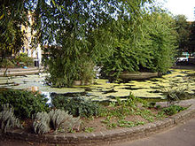
Clapton Pond from the South West corner

Clapton Pond is a pond and garden, located in Hackney, east London.

The name ‘Clapton’ or ‘farm on the hill’ is derived from the Old English words ‘clop’, a lump or hill, and ‘ton’ farm.

For centuries the land was owned by the Bishops of London, and occupied by tenant farmers who grew hay and food for the City of London.

The villages of Lower and Upper Clapton lay on either side of Clapton Lane, which later became the Lower and Upper Clapton Roads. Lying about half way between the two villages was Clapton Pond, fed by a natural spring. This would have been used to irrigate the land, and supply water for the farmers and their animals.

By the late 18th century Clapton had become a fashionable place to live, with many fine country houses built for the rich merchants of London. Huguenot and Jewish communities also moved into the area, helping to develop Clapton into a prosperous neighbourhood.

In the 19th century Clapton turned from being a sleepy backwater into a bustling London suburb and many of its grand houses were demolished to provide land for new homes. This rapid growth was increased by the opening of Clapton railway station in 1872, and the arrival of the tramways. By the 1890s, the houses on Thistlewaite, Newick and Mildenhall and Millfields Roads had been built, supplying much needed housing for newcomers.

Another view of Clapton Pond

Despite the decline of Clapton’s prosperity in the 1920s and 30s, the first half of the 20th century saw Clapton Pond at its most glorious, a perfect setting for the unique buildings situated behind the pond - the 17th-century Bishop Wood’s Almshouses, the late 18th-century Pond House and the two mid 18th-century houses.

The pond and gardens have always served as a focal point for the people of Clapton, from the few farmers who worked the land hundreds of years ago, to the multi-cultural community living and working in Clapton in the 21st century, who use it for public events and as a place to relax.

In recent years the Clapton Pond Neighbourhood Action Group have been working to renovate the pond.

External links

Coordinates: 51°33′22″N 0°03′18″W / 51.5561°N 0.0550°W / 51.5561; -0.0550


Wikimedia Foundation. 2010.

Игры ⚽ Нужна курсовая?

Look at other dictionaries:

  • Upper Clapton — Clapton, London redirects here. For other uses, see Clapton (disambiguation). Coordinates: 51°34′13″N 0°03′30″W / 51.5702°N 0.0583°W / …   Wikipedia

  • Pond Lane Flood Gates — Infobox Waterlock lock name=Pond Lane Flood Gates caption=Redundant flood gates, at the top of Hackney Cut, on the Lee Navigation. waterway=River Lee Navigation county=Hackney Greater London operation=redundant first= length= width= fall=… …   Wikipedia

  • Lower Clapton — Coordinates: 51°33′08″N 0°02′49″W / 51.55212°N 0.04704°W / 51.55212; 0.04704 …   Wikipedia

  • London Buses route 106 — Infobox London Bus number=106 operator=East London garage=West Ham vehicle=Dennis Trident 2/Alexander ALX400 pvr=18 start=Finsbury Park end=Whitechapel via=Stoke Newington Clapton Hackney length= 6 miles (9 km) level=Daily frequency=About every 7 …   Wikipedia

  • London Buses route 56 — Infobox London Bus number=56 operator=East London garage=Leyton vehicle=Dennis Trident 2 10.5m/Alexander ALX400 start=Whipps Cross end=St Bartholomew s Hospital via=Clapton Dalston Angel, Islington length=8 miles (12 km) level=Daily… …   Wikipedia

  • London Buses route 38 — Infobox London Bus number=38 operator=Arriva London length= 7 miles (12 km) time= 45 68 minutes garage=Ash Grove vehicle=Mercedes Benz O530G Citaro start=Clapton end=Victoria via=Hackney Islington Holborn Piccadilly Circus level=Daily… …   Wikipedia

  • List of night buses in London — Night buses in London are after hours versions of their daytime numerical equivalents, normally running the same route but with extensions at either end of the service. This is normally to provide a night service to destinations served by tube or …   Wikipedia

  • London Buses route 253 — Infobox London Bus number=253 ibus=yes operator=Arriva London garage=Stamford Hill (SF) vehicle=DAF DB250LF / Alexander ALX400 Volvo B7TL / Wright Eclipse Gemini pvr=25 start=Euston via=Mornington Crescent Camden Town Holloway Finsbury Park… …   Wikipedia

  • London Buses route 55 — Infobox London Bus number=55 operator=East London garage=Leyton vehicle= Dennis Trident 2 10.5 m / Alexander ALX400 start=Leyton Green end=Oxford Circus via= Clapton Hackney Shoreditch Clerkenwell length=9 miles (14 km) level=Daily… …   Wikipedia

  • London Buses route N38 — Infobox London Bus number=N38 operator=Arriva London garage=Stamford Hill (SF) vehicle=DAF DB250LF / Alexander ALX400 pvr=18 start=Victoria via=Clapton Hackney Islington Holborn Tottenham Court Road Trafalgar Square Hyde Park end=Walthamstow… …   Wikipedia

Share the article and excerpts

Direct link
Do a right-click on the link above
and select “Copy Link”