- Civil Parishes of Póvoa de Varzim
-
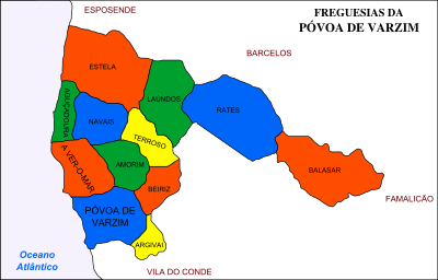 Map with the 12 civil parishes of Póvoa de Varzim
Póvoa de Varzim is divided into twelve civil parishes. These are grouped in two areas: urban (city) and rural. Between 1308 and 1836, the municipality was made up of a single parish territory of which, over time, approached the medieval borders.[1] In the 18th century, the Aver-o-Mar area (of the parish of Amorim) was annexed, by royal order, to a place in the north of Póvoa de Varzim, as it had to an increasing local population made up of fishing-farmers.
- With the administrative reform of the territory in 1836 Póvoa started to definitively control the territories: the council of Rates was annexed, the lands of Argivai recouped, and Balasar, Estela, Laundos, Navais, Terroso, Outeiro Maior, Parada, Rio Mau, and Santagões were acquired. In 1853, it exchanged the last four with the neighbouring Vila do Conde which got Amorim and Beiriz. The parishes of Aver-o-Mar and Aguçadoura were created in the beginning of 20th century through the dismemberment of Amorim and Navais, respectively.[2]
Civil parishes
- A Ver-o-Mar
- Aguçadoura
- Amorim
- Argivai
- Balasar
- Beiriz
- Estela
- Laundos
- Póvoa de Varzim
- Navais
- Rates
- Terroso
Hamlets
Each rural parish is further subdivided into Lugares or Localidades which can be translated into locations, villages or hamlets, some of which in recent periods became urbanized or merged with neighboring villages.
Agra Agra de Bouças Agro-Velho Águas Férreas Aguçadoura Aldeia Aldeia Nova Além Amorim Amorim de Cima Areosa Argivai A Ver-o-Mar Balazar Barranha Barreiros Barros Beiriz Beiriz de Baixo Boavista Borgonha Bouça Velha Boucinha Burgada Caçapos Calvário Calves Caminho Largo Caramujo Carregal Carregosa Carvalheiro Casal Casal do Monte Castelo Catiosa Caturela Chamozinhos Codixeira Comão Contriz Cruz Cuteres Eirado Escaris Espedelos Espinhal Estela Estrada Estrada Nova Faroleiro Finisterra Fontainha Fontainhas Fontela Fonte Nova Fontes Novas Fraião Fringio Gândara Gandra Gestrins Giesteira Granja Granjeiro Gresufes Guardais Guardinhas Guardinhos Igreja Laundos Lousadelo Machoqueira Magosa Mandim Mão Pedrosa Martinho Moinhos da Senra Moninhas Monte Tapado Morincheira Mourilhe Navais Nossa Senhora dos Passos Nova Sintra Oliveira Outeiro Paço Padrão Paimo Palmeiro Paralheira Paranho Paranho da Areia Paranho de Cima Paredes Passo Pé do Monte Pedreira Pedrinha Pedroso Pelames Penouces Pereira Perlinha Pincelos Portela Póvoas Praça Preladas Quião Quinta Quintela Rapijães Rates Refojos Regufe Salgueiras Sandim Santo André Santo António São Braz São Félix São Lourenço São Salvador São Tiago Sapogães Sejães Sencadas Senhora da Cruz Senhora da Saúde Senhora de Fátima Senhora do Bom Fim Serra Serra do Monte Sijais Sistelos Sonhim Terra Ruim Terroso Teso Torrinha Travassos Urzes Valdoia Vela Vila Pouca Vilar Zimbelo References
- ^ Amorim, Manuel: A Póvoa Antiga Na Linha do horizonte - Biblioteca Poveira CMPV, 2003
- ^ "Turismo: Conhecer a Póvoa, História" (in Portuguese). CMPV. http://www.cm-pvarzim.pt/turismo/conhecer-a-povoa/historia/. Retrieved September 9, 2006.
Rural Categories:- Parishes of Póvoa de Varzim

Wikimedia Foundation. 2010.