Church of St Mary the Virgin, Barrington

Church of St Mary the Virgin, Barrington
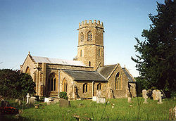
Location: Barrington, Somerset, England
Coordinates: 50°57′34″N 2°52′16″W / 50.95944°N 2.87111°W / 50.95944; -2.87111Coordinates: 50°57′34″N 2°52′16″W / 50.95944°N 2.87111°W / 50.95944; -2.87111
Built: 13th century
Listed Building – Grade I
Designated: 17 April 1959[1]
Reference #: 264319
Church of St Mary the Virgin, Barrington is located in Somerset
{{{alt}}}
Location of Church of St Mary the Virgin, Barrington in Somerset

The Church of St Mary the Virgin in Barrington, Somerset, England dates from the 13th century and has been designated as a Grade I listed building.[1]

St Mary's Church has a three bay nave two bay chancel.[1] There is an unusual octagonal tower, which includes a bell dating from 1743 and made by Thomas Bilbie of the Bilbie family.[2]

The south transept includes a 13th century canopied piscina. There is a 19th century panelled pulpit which may contain fragments of an earlier construction.[1]

The parish is part of the benefice of Winsmoor within the deanery of Crewkerne and Ilminster.[3]

See also

References

  1. ^ a b c d "Church of St. Mary the Virgin". Images of England. http://www.imagesofengland.org.uk/details/default.aspx?id=264319. Retrieved 5 October 2007. 
  2. ^ Moore, James; Roy Rice & Ernest Hucker (1995). Bilbie and the Chew Valley clock makers. The authors. ISBN 0952670208. 
  3. ^ "The Blessed Virgin Mary, Barrington". Churhc of England. http://www.achurchnearyou.com/barrington-the-blessed-virgin-mary/. Retrieved 12 September 2011. 

Wikimedia Foundation. 2010.

Игры ⚽ Поможем решить контрольную работу

Look at other dictionaries:

  • Barrington, Somerset — infobox UK place country= England latitude= 50.9626 longitude= 2.8770 official name= Barrington population= 427. [cite web | title=2002 Population estimates | work=Somerset County Council | url=http://www.somerset.gov.uk/somerset/statistics/conten… …   Wikipedia

  • St. Mary's Church — Contents 1 Albania 2 Azerbaijan 3 Belarus 4 Bosnia and …   Wikipedia

  • List of Grade I listed buildings in Somerset — There are over 6000 Grade I listed buildings in England. This page is a list of these buildings in the county of Somerset.Bath North East Somerset* Abbey Church, Bath (Grade A) * Abbey Church Yard, Bath: No 14 * Grand Pump Room, Bath * Grand Pump …   Wikipedia

  • List of Grade I listed buildings in Cambridgeshire — There are over 6000 Grade I listed buildings in England. This page is a list of these buildings in the county of Cambridgeshire, sub divided by district.Cambridge* Church of St Andrew, Cambridge * Little Trinity, Cambridge * Little Trinity:… …   Wikipedia

  • Chard, Somerset — Coordinates: 50°52′22″N 2°57′31″W / 50.8728°N 2.9587°W / 50.8728; 2.9587 …   Wikipedia

  • Norton Sub Hamdon — Coordinates: 50°56′26″N 2°45′20″W / 50.9406°N 2.7555°W / 50.9406; 2.7555 …   Wikipedia

  • Whitelackington — Dillington redirects here. For other uses, see Dillington (disambiguation). Coordinates: 50°56′08″N 2°52′35″W / 50.9356°N 2.8765°W / …   Wikipedia

  • Mudford — Coordinates: 50°58′24″N 2°36′24″W / 50.9733°N 2.6066°W / 50.9733; 2.6066 …   Wikipedia

  • Nettlecombe Court — Field Centre …   Wikipedia

  • United States District Court for the District of Columbia — Not to be confused with Superior Court of the District of Columbia. Supreme Court of the District of Columbia redirects here. For the court of last resort for the District of Columbia, see District of Columbia Court of Appeals. United States… …   Wikipedia

Share the article and excerpts

Direct link
Do a right-click on the link above
and select “Copy Link”